
Topografische Karte Sas de Stria
Interaktive Karte
Klicken Sie auf die Karte, um die Höhe anzuzeigen.
Sas de Stria
Sass de Stria is a mountain of the Veneto, Italy. It has an elevation of 2,477 meters. During the First World War, the mountain and surrounding area was the scene of fighting between Italy and Austria-Hungary.
Über diese Karte
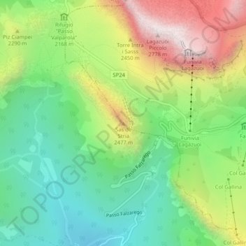
Name: Topografische Karte Sas de Stria, Höhe, Relief.
Ort: Sas de Stria, Cortina d'Ampezzo, Belluno, Veneto, Italy (46.51988 11.99782 46.51998 11.99792)
Durchschnittliche Höhe: 2.138 m
Minimale Höhe: 1.751 m
Maximale Höhe: 2.757 m