
Topografische Karte Pocatello
Interaktive Karte
Klicken Sie auf die Karte, um die Höhe anzuzeigen.
Über diese Karte
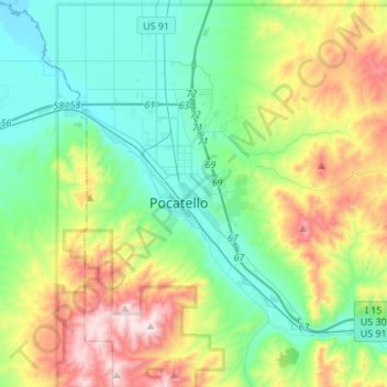
Name: Topografische Karte Pocatello, Höhe, Relief.
Ort: Pocatello, Bannock County, Idaho, United States (42.80215 -112.63186 42.93149 -112.36026)
Durchschnittliche Höhe: 1.580 m
Minimale Höhe: 1.328 m
Maximale Höhe: 2.209 m
Pocatello is the fifth-largest city in the state, just behind Idaho Falls. In 2007, Pocatello was ranked twentieth on Forbes' list of Best Small Places for Business and Careers. Pocatello is the home of Idaho State University and the manufacturing facility of ON Semiconductor. The city is at an elevation of 4,462 feet (1.360 km) above sea level and is served by the Pocatello Regional Airport.
Andere topografische Karten
Klicken Sie auf eine Karte, um ihre Topografie, ihre Höhe und ihr Relief anzuzeigen.
Fort Hall
United States > Idaho > Bannock County
Fort Hall, Bannock County, Idaho, United States
Durchschnittliche Höhe: 1.377 m
Lava Hot Springs
United States > Idaho > Bannock County
Lava Hot Springs, Bannock County, Idaho, 83246, United States
Durchschnittliche Höhe: 1.611 m