
Topografische Karte Atkins
Interaktive Karte
Klicken Sie auf die Karte, um die Höhe anzuzeigen.
Über diese Karte
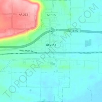
Name: Topografische Karte Atkins, Höhe, Relief.
Ort: Atkins, Pope County, Arkansas, 72823, United States (35.21727 -92.98756 35.26822 -92.92493)
Durchschnittliche Höhe: 131 m
Minimale Höhe: 91 m
Maximale Höhe: 286 m
Andere topografische Karten
Klicken Sie auf eine Karte, um ihre Topografie, ihre Höhe und ihr Relief anzuzeigen.
Russellville
United States > Arkansas > Pope County
Russellville, Pope County, Arkansas, United States
Durchschnittliche Höhe: 133 m
Pottsville
United States > Arkansas > Pope County
Pottsville, Pope County, Arkansas, 72858, United States
Durchschnittliche Höhe: 120 m
Holla Bend
United States > Arkansas > Pope County > Pottsville
Holla Bend, Pottsville, Pope County, Arkansas, 72858, United States
Durchschnittliche Höhe: 98 m
Dover
United States > Arkansas > Pope County
Dover, Pope County, Arkansas, 72837, United States
Durchschnittliche Höhe: 164 m
Dover
United States > Arkansas > Pope County > Dover > Dover
Dover, Pope County, Arkansas, 72837, United States
Durchschnittliche Höhe: 150 m
Buttermilk
United States > Arkansas > Pope County > Buttermilk
Buttermilk, Pope County, Arkansas, United States
Durchschnittliche Höhe: 164 m
Bernice
United States > Arkansas > Pope County > Russellville
Bernice, Russellville, Pope County, Arkansas, 72801, United States
Durchschnittliche Höhe: 114 m