Geolokalisieren

Topografische Karte Kurki

Interaktive Karte

Klicken Sie auf die Karte, um die Höhe anzuzeigen.

Über diese Karte

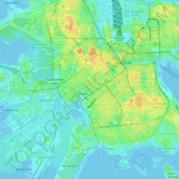
Name: Topografische Karte Kurki, Höhe, Relief.

Ort: Kurki, Hietalahti, Kamppi, Southern major district, Helsinki, Helsinki sub-region, Uusimaa, Southern Finland, Mainland Finland, 00180, Finland (60.16253 24.93031 60.16436 24.93427)

Durchschnittliche Höhe: 12 m

Minimale Höhe: -4 m

Maximale Höhe: 38 m

Andere topografische Karten

Klicken Sie auf eine Karte, um ihre Topografie, ihre Höhe und ihr Relief anzuzeigen.

Kalasatama

Finland > Uusimaa > Helsinki

Kalasatama, Sörnäinen, Central major district, Helsinki, Helsinki sub-region, Uusimaa, Southern Finland, Mainland Finland, Finland

Durchschnittliche Höhe: 8 m

Viikki

Finland > Uusimaa > Helsinki

Viikki, Northeastern major district, Helsinki, Helsinki sub-region, Uusimaa, Southern Finland, Mainland Finland, Finland

Durchschnittliche Höhe: 13 m

Kyyhkynen

Finland > Uusimaa > Helsinki

Kyyhkynen, Hietalahti, Kamppi, Southern major district, Helsinki, Helsinki sub-region, Uusimaa, Southern Finland, Mainland Finland, 00180, Finland

Durchschnittliche Höhe: 11 m

Malmi

Finland > Uusimaa > Helsinki

Malmi, Northeastern major district, Helsinki, Helsinki sub-region, Uusimaa, Southern Finland, Mainland Finland, Finland

Durchschnittliche Höhe: 19 m

Munkkiniemi

Finland > Uusimaa > Helsinki

Munkkiniemi, Western major district, Helsinki, Helsinki sub-region, Uusimaa, Southern Finland, Mainland Finland, Finland

Durchschnittliche Höhe: 8 m