
Topografische Karte Ratière
Interaktive Karte
Klicken Sie auf die Karte, um die Höhe anzuzeigen.
Über diese Karte
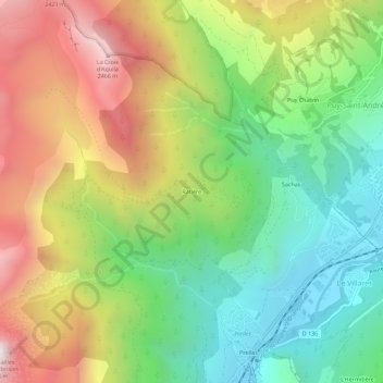
Name: Topografische Karte Ratière, Höhe, Relief.
Durchschnittliche Höhe: 1.723 m
Minimale Höhe: 1.140 m
Maximale Höhe: 2.534 m
Andere topografische Karten
Klicken Sie auf eine Karte, um ihre Topografie, ihre Höhe und ihr Relief anzuzeigen.
Sainte-Marguerite
France > Provence-Alpes-Côte d'Azur > Hautes-Alpes > Saint-Martin-de-Queyrières
Sainte-Marguerite, Saint-Martin-de-Queyrières, Briançon, Hautes-Alpes, Provence-Alpes-Côte d'Azur, France métropolitaine, 05120, France
Durchschnittliche Höhe: 1.453 m
Roche Baron
France > Provence-Alpes-Côte d'Azur > Hautes-Alpes > Saint-Martin-de-Queyrières
Roche Baron, Saint-Martin-de-Queyrières, Briançon, Hautes-Alpes, Provence-Alpes-Côte d'Azur, France métropolitaine, 05120, France
Durchschnittliche Höhe: 1.512 m
La Salcette
France > Provence-Alpes-Côte d'Azur > Hautes-Alpes > Saint-Martin-de-Queyrières
La Salcette, Saint-Martin-de-Queyrières, Briançon, Hautes-Alpes, Provence-Alpes-Côte d'Azur, France métropolitaine, 05120, France
Durchschnittliche Höhe: 1.834 m