
Topografische Karte Amareleja
Interaktive Karte
Klicken Sie auf die Karte, um die Höhe anzuzeigen.
Über diese Karte
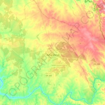
Name: Topografische Karte Amareleja, Höhe, Relief.
Ort: Amareleja, Moura, Beja, Portugal (38.13805 -7.29335 38.28182 -7.15203)
Durchschnittliche Höhe: 198 m
Minimale Höhe: 101 m
Maximale Höhe: 305 m
Andere topografische Karten
Klicken Sie auf eine Karte, um ihre Topografie, ihre Höhe und ihr Relief anzuzeigen.
Moura (Santo Agostinho e São João Batista) e Santo Amador
Moura (Santo Agostinho e São João Batista) e Santo Amador, Moura, Beja, Portugal
Durchschnittliche Höhe: 184 m
Descarga de Superficie
Descarga de Superficie, Moura (Santo Agostinho e São João Batista) e Santo Amador, Moura, Beja, 7830-286, Portugal
Durchschnittliche Höhe: 227 m