
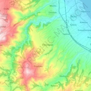
Topografische Karte Municipal Unit of Velos
Interaktive Karte
Klicken Sie auf die Karte, um die Höhe anzuzeigen.
Über diese Karte
Name: Topografische Karte Municipal Unit of Velos, Höhe, Relief.
Durchschnittliche Höhe: 276 m
Minimale Höhe: 0 m
Maximale Höhe: 821 m
Andere topografische Karten
Klicken Sie auf eine Karte, um ihre Topografie, ihre Höhe und ihr Relief anzuzeigen.
Municipal Unit of Evrostina
Greece > Peloponnese, Western Greece and the Ionian > Corinthia Regional Unit
Municipal Unit of Evrostina, Municipality of Xylokastro and Evrostina, Corinthia Regional Unit, Peloponnese Region, Peloponnese, Western Greece and the Ionian, Greece
Durchschnittliche Höhe: 699 m
Σούλι
Greece > Peloponnese, Western Greece and the Ionian > Corinthia Regional Unit > Municipal Unit of Sikyona
Σούλι, Municipal Unit of Sikyona, Municipality of Sikyona, Corinthia Regional Unit, Peloponnese Region, Peloponnese, Western Greece and the Ionian, 200 15, Greece
Durchschnittliche Höhe: 597 m
Municipal Unit of Corinth
Greece > Peloponnese, Western Greece and the Ionian > Corinthia Regional Unit
Municipal Unit of Corinth, Municipality of Corinth, Corinthia Regional Unit, Peloponnese Region, Peloponnese, Western Greece and the Ionian, Greece
Durchschnittliche Höhe: 126 m
Kyllini (Ziria)
Greece > Peloponnese, Western Greece and the Ionian > Corinthia Regional Unit > Municipal Unit of Xylokastro
Kyllini (Ziria), Municipal Unit of Xylokastro, Municipality of Xylokastro and Evrostina, Corinthia Regional Unit, Peloponnese Region, Peloponnese, Western Greece and the Ionian, Greece
Durchschnittliche Höhe: 1.994 m
Corinth Canal
Greece > Peloponnese, Western Greece and the Ionian > Corinthia Regional Unit > Municipal Unit of Loutraki - Perachora > Γαλότα
Corinth Canal, Γαλότα, Community of Loutraki - Perachora, Municipal Unit of Loutraki - Perachora, Loutraki-Perachora-Agioi Theodoroi Municipality, Corinthia Regional Unit, Peloponnese Region, Peloponnese, Western Greece and the Ionian, Greece
Durchschnittliche Höhe: 61 m
Community of Ano Trikala
Greece > Peloponnese, Western Greece and the Ionian > Corinthia Regional Unit > Municipal Unit of Xylokastro
Community of Ano Trikala, Municipal Unit of Xylokastro, Municipality of Xylokastro and Evrostina, Corinthia Regional Unit, Peloponnese Region, Peloponnese, Western Greece and the Ionian, Greece
Durchschnittliche Höhe: 1.551 m
Corinth
Greece > Peloponnese, Western Greece and the Ionian > Corinthia Regional Unit
Corinth, Municipal Unit of Corinth, Municipality of Corinth, Corinthia Regional Unit, Peloponnese Region, Peloponnese, Western Greece and the Ionian, 201 00, Greece
Durchschnittliche Höhe: 185 m
Νεμέα
Greece > Peloponnese, Western Greece and the Ionian > Corinthia Regional Unit > Νεμέα
Νεμέα, Municipality of Nemea, Corinthia Regional Unit, Peloponnese Region, Peloponnese, Western Greece and the Ionian, 20500, Greece
Durchschnittliche Höhe: 401 m
Kiato
Greece > Peloponnese, Western Greece and the Ionian > Corinthia Regional Unit > Municipal Unit of Sikyona
Kiato, Municipal Unit of Sikyona, Municipality of Sikyona, Corinthia Regional Unit, Peloponnese Region, Peloponnese, Western Greece and the Ionian, 202 00, Greece
Durchschnittliche Höhe: 32 m