
Topografische Karte Abucay
Interaktive Karte
Klicken Sie auf die Karte, um die Höhe anzuzeigen.
Über diese Karte
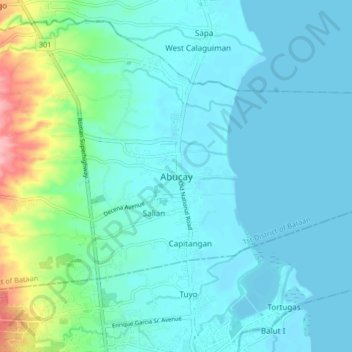
Name: Topografische Karte Abucay, Höhe, Relief.
Ort: Abucay, Bataan, Central Luzon, 2114, Philippines (14.68131 120.49487 14.76131 120.57487)
Durchschnittliche Höhe: 22 m
Minimale Höhe: 0 m
Maximale Höhe: 129 m
Topography of Abucay varies from the mountainous terrain of Mount Natib caldera in the west to the coastal areas of the province along the shore of Manila Bay. Six rivers with a combined length of 37 kilometres (23 mi) originate from the mountain flowing in the west-to-east direction.