
Spenden
Rüsten Sie sich für Ihr nächstes Abenteuer:
Als Amazon-Partner erhält diese Website eine Provision für qualifizierte Käufe, ohne zusätzliche Kosten für Sie.
Topografische Karte Thompson River
Klicken Sie auf die Karte, um die Höhe anzuzeigen.
Spenden
Rüsten Sie sich für Ihr nächstes Abenteuer:
Als Amazon-Partner erhält diese Website eine Provision für qualifizierte Käufe, ohne zusätzliche Kosten für Sie.
Über diese Karte
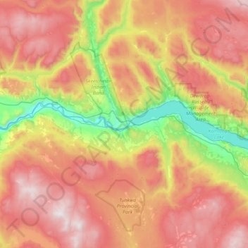
Name: Topografische Karte Thompson River, Höhe, Relief.
Durchschnittliche Höhe: 1.127 m
Minimale Höhe: 296 m
Maximale Höhe: 1.996 m
Spenden
Rüsten Sie sich für Ihr nächstes Abenteuer:
Als Amazon-Partner erhält diese Website eine Provision für qualifizierte Käufe, ohne zusätzliche Kosten für Sie.
Andere topografische Karten
Klicken Sie auf eine Karte, um ihre Topografie, ihre Höhe und ihr Relief anzuzeigen.
Kamloops
Canada > British Columbia > Thompson-Nicola Regional District > Kamloops
Durchschnittliche Höhe: 875 m
70 Mile House
Canada > British Columbia > Thompson-Nicola Regional District > Area E (Bonaparte Plateau)
Durchschnittliche Höhe: 1.087 m
Spenden
Rüsten Sie sich für Ihr nächstes Abenteuer:
Als Amazon-Partner erhält diese Website eine Provision für qualifizierte Käufe, ohne zusätzliche Kosten für Sie.
Lundbom Lake
Canada > British Columbia > Thompson-Nicola Regional District > Area N (Beautiful Nicola Valley - South)
Durchschnittliche Höhe: 1.158 m
Lytton
Canada > British Columbia > Thompson-Nicola Regional District
Lytton experiences an inland hot-summer mediterranean climate (Csa), using the -3 °C isotherm, or a dry-summer continental climate (Dsa), using the 0 °C isotherm. During summer heat waves, Lytton is often the hottest spot in Canada, despite its location north of 50°N in latitude. Because of the dry summer…
Durchschnittliche Höhe: 523 m
Area J (Copper Desert Country)
Canada > British Columbia > Thompson-Nicola Regional District
Durchschnittliche Höhe: 1.128 m
Westwold
Canada > British Columbia > Thompson-Nicola Regional District > Area L (Grasslands)
Durchschnittliche Höhe: 649 m
Spenden
Rüsten Sie sich für Ihr nächstes Abenteuer:
Als Amazon-Partner erhält diese Website eine Provision für qualifizierte Käufe, ohne zusätzliche Kosten für Sie.
Spences Bridge
Canada > British Columbia > Thompson-Nicola Regional District > Area I (Blue Sky Country)
Spences Bridge's location is mountainous, with higher elevations part of the Interior Plateau. The east side of the Fraser here is part of the Clear Range, a mountainous southwards extension of the Fraser Plateau located in the angle of the Thompson and Fraser Rivers. Arthur Seat lies in that range on the west…
Durchschnittliche Höhe: 496 m
Mount St. Anne
Canada > British Columbia > Thompson-Nicola Regional District > Area B (Thompson Headwaters)
Durchschnittliche Höhe: 1.901 m
Shackan Indian Band
Canada > British Columbia > Thompson-Nicola Regional District
Durchschnittliche Höhe: 870 m
Thompson River
Canada > British Columbia > Thompson-Nicola Regional District
Durchschnittliche Höhe: 1.149 m
Spenden
Rüsten Sie sich für Ihr nächstes Abenteuer:
Als Amazon-Partner erhält diese Website eine Provision für qualifizierte Käufe, ohne zusätzliche Kosten für Sie.
Fire Mountain
Canada > British Columbia > Thompson-Nicola Regional District > Area A (Wells Gray Country)
Kostal Cone, also called Kostal Volcano and Fire Mountain, is a young cinder cone in Wells Gray Provincial Park in east-central British Columbia, Canada. It rises from the northeast shore of Kostal Lake in the Cariboo Mountains. With an elevation of 1,440 m (4,724 ft), Kostal Cone is one of the lowest…
Durchschnittliche Höhe: 1.316 m
Dragon Cone
Canada > British Columbia > Thompson-Nicola Regional District > Area A (Wells Gray Country)
Durchschnittliche Höhe: 1.703 m
McLeod Hill
Canada > British Columbia > Thompson-Nicola Regional District > Area A (Wells Gray Country)
Durchschnittliche Höhe: 1.133 m
Spenden
Rüsten Sie sich für Ihr nächstes Abenteuer:
Als Amazon-Partner erhält diese Website eine Provision für qualifizierte Käufe, ohne zusätzliche Kosten für Sie.
Clearwater
Canada > British Columbia > Thompson-Nicola Regional District
Durchschnittliche Höhe: 1.098 m
Dardanelles Lake
Canada > British Columbia > Thompson-Nicola Regional District > Area M (Beautiful Nicola Valley - North)
Durchschnittliche Höhe: 1.269 m
Sun Peaks
Canada > British Columbia > Thompson-Nicola Regional District > Sun Peaks Mountain Resort Municipality
Durchschnittliche Höhe: 1.490 m
Tunkwa Provincial Park
Canada > British Columbia > Thompson-Nicola Regional District > Area J (Copper Desert Country)
Durchschnittliche Höhe: 1.226 m
Spenden
Rüsten Sie sich für Ihr nächstes Abenteuer:
Als Amazon-Partner erhält diese Website eine Provision für qualifizierte Käufe, ohne zusätzliche Kosten für Sie.
Mount Cahilty
Canada > British Columbia > Thompson-Nicola Regional District > Area O (Lower North Thompson)
Durchschnittliche Höhe: 1.736 m
Whitecroft
Canada > British Columbia > Thompson-Nicola Regional District > Area P (Rivers and the Peaks)
Durchschnittliche Höhe: 1.000 m
Kingsvale
Canada > British Columbia > Thompson-Nicola Regional District > Area N (Beautiful Nicola Valley - South)
Durchschnittliche Höhe: 928 m
Spenden
Rüsten Sie sich für Ihr nächstes Abenteuer:
Als Amazon-Partner erhält diese Website eine Provision für qualifizierte Käufe, ohne zusätzliche Kosten für Sie.
Bonaparte Lake
Canada > British Columbia > Thompson-Nicola Regional District > Area O (Lower North Thompson)
Durchschnittliche Höhe: 1.383 m
Area M (Beautiful Nicola Valley - North)
Canada > British Columbia > Thompson-Nicola Regional District
Durchschnittliche Höhe: 1.161 m
Vimy Ridge
Canada > British Columbia > Thompson-Nicola Regional District > Area A (Wells Gray Country)
Durchschnittliche Höhe: 1.871 m
Spenden
Rüsten Sie sich für Ihr nächstes Abenteuer:
Als Amazon-Partner erhält diese Website eine Provision für qualifizierte Käufe, ohne zusätzliche Kosten für Sie.
Big OK Lake (Island Lake) Recreation Site
Canada > British Columbia > Thompson-Nicola Regional District > Logan Lake
Durchschnittliche Höhe: 1.540 m
Chasm
Canada > British Columbia > Thompson-Nicola Regional District > Area E (Bonaparte Plateau)
Durchschnittliche Höhe: 1.063 m
Area E (Bonaparte Plateau)
Canada > British Columbia > Thompson-Nicola Regional District
Durchschnittliche Höhe: 1.215 m
Mamit Lake
Canada > British Columbia > Thompson-Nicola Regional District > Area M (Beautiful Nicola Valley - North)
Durchschnittliche Höhe: 1.122 m
Spenden
Rüsten Sie sich für Ihr nächstes Abenteuer:
Als Amazon-Partner erhält diese Website eine Provision für qualifizierte Käufe, ohne zusätzliche Kosten für Sie.
Cache Creek
Canada > British Columbia > Thompson-Nicola Regional District
Durchschnittliche Höhe: 658 m
Little Heffley Lake
Canada > British Columbia > Thompson-Nicola Regional District > Area P (Rivers and the Peaks)
Durchschnittliche Höhe: 1.035 m
Savona
Canada > British Columbia > Thompson-Nicola Regional District > Area J (Copper Desert Country)
Durchschnittliche Höhe: 480 m
Green Lake
Canada > British Columbia > Thompson-Nicola Regional District > Area E (Bonaparte Plateau)
Durchschnittliche Höhe: 1.111 m
Spenden
Rüsten Sie sich für Ihr nächstes Abenteuer:
Als Amazon-Partner erhält diese Website eine Provision für qualifizierte Käufe, ohne zusätzliche Kosten für Sie.
Pinantan Lake
Canada > British Columbia > Thompson-Nicola Regional District > Area P (Rivers and the Peaks)
Durchschnittliche Höhe: 971 m
Logan Lake
Canada > British Columbia > Thompson-Nicola Regional District
Durchschnittliche Höhe: 1.398 m
Greenstone Mountain
Canada > British Columbia > Thompson-Nicola Regional District > Area J (Copper Desert Country)
Durchschnittliche Höhe: 1.624 m
Brookmere
Canada > British Columbia > Thompson-Nicola Regional District > Area N (Beautiful Nicola Valley - South)
Durchschnittliche Höhe: 1.152 m
Spenden
Rüsten Sie sich für Ihr nächstes Abenteuer:
Als Amazon-Partner erhält diese Website eine Provision für qualifizierte Käufe, ohne zusätzliche Kosten für Sie.
Mount Tod
Canada > British Columbia > Thompson-Nicola Regional District > Sun Peaks Mountain Resort Municipality
Durchschnittliche Höhe: 1.925 m
Area E (Bonaparte Plateau)
Canada > British Columbia > Thompson-Nicola Regional District
Durchschnittliche Höhe: 1.215 m
Area L (Grasslands)
Canada > British Columbia > Thompson-Nicola Regional District
Durchschnittliche Höhe: 1.020 m
Kamloops Lake
Canada > British Columbia > Thompson-Nicola Regional District > Area J (Copper Desert Country)
Durchschnittliche Höhe: 975 m
Spenden
Rüsten Sie sich für Ihr nächstes Abenteuer:
Als Amazon-Partner erhält diese Website eine Provision für qualifizierte Käufe, ohne zusätzliche Kosten für Sie.
Red Lake
Canada > British Columbia > Thompson-Nicola Regional District > Area J (Copper Desert Country)
Durchschnittliche Höhe: 1.036 m
Area N (Beautiful Nicola Valley - South)
Canada > British Columbia > Thompson-Nicola Regional District
Durchschnittliche Höhe: 1.227 m
Adams Lake
Canada > British Columbia > Thompson-Nicola Regional District > Area O (Lower North Thompson)
According to one account, the lake is 63 kilometres (39 mi) long and 1.6 to 3.2 kilometres (1.0 to 2.0 mi) wide. The surface elevation is 404 metres (1,325 ft) above sea level. The mean depth of 299 metres (981 ft) and maximum depth of 457 metres (1,499 ft) make the second deepest lake in BC (next to Quesnel…
Durchschnittliche Höhe: 1.177 m
Area P (Rivers and the Peaks)
Canada > British Columbia > Thompson-Nicola Regional District
Durchschnittliche Höhe: 1.025 m
Spenden
Rüsten Sie sich für Ihr nächstes Abenteuer:
Als Amazon-Partner erhält diese Website eine Provision für qualifizierte Käufe, ohne zusätzliche Kosten für Sie.
Lytton
Canada > British Columbia > Thompson-Nicola Regional District
Lytton experiences an inland hot-summer mediterranean climate (Csa), using the -3 °C isotherm, or a dry-summer continental climate (Dsa), using the 0 °C isotherm. During summer heat waves, Lytton is often the hottest spot in Canada, despite its location north of 50°N in latitude. Because of the dry summer…
Durchschnittliche Höhe: 523 m
Logan Lake
Canada > British Columbia > Thompson-Nicola Regional District
Durchschnittliche Höhe: 1.398 m
Area M (Beautiful Nicola Valley - North)
Canada > British Columbia > Thompson-Nicola Regional District
Durchschnittliche Höhe: 1.161 m
Area A (Wells Gray Country)
Canada > British Columbia > Thompson-Nicola Regional District
Durchschnittliche Höhe: 1.453 m
Spenden
Rüsten Sie sich für Ihr nächstes Abenteuer:
Als Amazon-Partner erhält diese Website eine Provision für qualifizierte Käufe, ohne zusätzliche Kosten für Sie.
Black Dome Mountain
Canada > British Columbia > Thompson-Nicola Regional District > Area E (Bonaparte Plateau)
Durchschnittliche Höhe: 1.931 m
Tunkwa Lake
Canada > British Columbia > Thompson-Nicola Regional District > Area J (Copper Desert Country)
Durchschnittliche Höhe: 1.161 m
Lac Le Jeune Provincial Park
Canada > British Columbia > Thompson-Nicola Regional District > Area J (Copper Desert Country)
Durchschnittliche Höhe: 1.308 m
Edith Lake
Canada > British Columbia > Thompson-Nicola Regional District > Area J (Copper Desert Country)
Durchschnittliche Höhe: 1.054 m
Spenden
Rüsten Sie sich für Ihr nächstes Abenteuer:
Als Amazon-Partner erhält diese Website eine Provision für qualifizierte Käufe, ohne zusätzliche Kosten für Sie.
Kentucky-Alleyne Provincial Park
Canada > British Columbia > Thompson-Nicola Regional District > Area N (Beautiful Nicola Valley - South)
Durchschnittliche Höhe: 1.095 m
Isobel Lake
Canada > British Columbia > Thompson-Nicola Regional District > Area J (Copper Desert Country)
Durchschnittliche Höhe: 1.058 m
Roche Lake
Canada > British Columbia > Thompson-Nicola Regional District > Area L (Grasslands)
Durchschnittliche Höhe: 1.164 m
Arthur Seat
Canada > British Columbia > Thompson-Nicola Regional District > Area I (Blue Sky Country)
Durchschnittliche Höhe: 1.327 m
Spenden
Rüsten Sie sich für Ihr nächstes Abenteuer:
Als Amazon-Partner erhält diese Website eine Provision für qualifizierte Käufe, ohne zusätzliche Kosten für Sie.
Quilchena
Canada > British Columbia > Thompson-Nicola Regional District > Area M (Beautiful Nicola Valley - North)
Durchschnittliche Höhe: 677 m
Area O (Lower North Thompson)
Canada > British Columbia > Thompson-Nicola Regional District
Durchschnittliche Höhe: 1.159 m
Lower Nicola
Canada > British Columbia > Thompson-Nicola Regional District > Area M (Beautiful Nicola Valley - North)
Durchschnittliche Höhe: 649 m
Roper Hill
Canada > British Columbia > Thompson-Nicola Regional District > Area J (Copper Desert Country)
Durchschnittliche Höhe: 486 m
Spenden
Rüsten Sie sich für Ihr nächstes Abenteuer:
Als Amazon-Partner erhält diese Website eine Provision für qualifizierte Käufe, ohne zusätzliche Kosten für Sie.
Highland Valley
Canada > British Columbia > Thompson-Nicola Regional District > Logan Lake
Durchschnittliche Höhe: 1.190 m
Spences Bridge
Canada > British Columbia > Thompson-Nicola Regional District > Area I (Blue Sky Country)
Spences Bridge's location is mountainous, with higher elevations part of the Interior Plateau. The east side of the Fraser here is part of the Clear Range, a mountainous southwards extension of the Fraser Plateau located in the angle of the Thompson and Fraser Rivers. Arthur Seat lies in that range on the west…
Durchschnittliche Höhe: 496 m
Clearwater
Canada > British Columbia > Thompson-Nicola Regional District
Durchschnittliche Höhe: 1.098 m
Spenden
Rüsten Sie sich für Ihr nächstes Abenteuer:
Als Amazon-Partner erhält diese Website eine Provision für qualifizierte Käufe, ohne zusätzliche Kosten für Sie.
Area I (Blue Sky Country)
Canada > British Columbia > Thompson-Nicola Regional District
Durchschnittliche Höhe: 1.311 m
Sun Peaks
Canada > British Columbia > Thompson-Nicola Regional District > Sun Peaks Mountain Resort Municipality
Durchschnittliche Höhe: 1.490 m
Paul Lake
Canada > British Columbia > Thompson-Nicola Regional District > Area P (Rivers and the Peaks)
Durchschnittliche Höhe: 926 m
Spenden
Rüsten Sie sich für Ihr nächstes Abenteuer:
Als Amazon-Partner erhält diese Website eine Provision für qualifizierte Käufe, ohne zusätzliche Kosten für Sie.
Aspen Grove
Canada > British Columbia > Thompson-Nicola Regional District > Area N (Beautiful Nicola Valley - South)
Durchschnittliche Höhe: 1.165 m
Vavenby
Canada > British Columbia > Thompson-Nicola Regional District > Area A (Wells Gray Country)
Durchschnittliche Höhe: 642 m
Roche Lake
Canada > British Columbia > Thompson-Nicola Regional District > Area L (Grasslands)
Durchschnittliche Höhe: 1.164 m
Pritchard
Canada > British Columbia > Thompson-Nicola Regional District > Area P (Rivers and the Peaks)
Durchschnittliche Höhe: 433 m
Spenden
Rüsten Sie sich für Ihr nächstes Abenteuer:
Als Amazon-Partner erhält diese Website eine Provision für qualifizierte Käufe, ohne zusätzliche Kosten für Sie.
Dunn Peak
Canada > British Columbia > Thompson-Nicola Regional District > Area O (Lower North Thompson)
Durchschnittliche Höhe: 2.132 m
Mount Knouff
Canada > British Columbia > Thompson-Nicola Regional District > Area P (Rivers and the Peaks)
Durchschnittliche Höhe: 1.225 m
Skeetchestn Indian Band
Canada > British Columbia > Thompson-Nicola Regional District > Area J (Copper Desert Country)
Durchschnittliche Höhe: 1.091 m
Blue River
Canada > British Columbia > Thompson-Nicola Regional District > Area B (Thompson Headwaters)
Durchschnittliche Höhe: 710 m
Spenden
Rüsten Sie sich für Ihr nächstes Abenteuer:
Als Amazon-Partner erhält diese Website eine Provision für qualifizierte Käufe, ohne zusätzliche Kosten für Sie.
Community Lake
Canada > British Columbia > Thompson-Nicola Regional District > Area O (Lower North Thompson)
Durchschnittliche Höhe: 1.399 m
Badger Lake
Canada > British Columbia > Thompson-Nicola Regional District > Area P (Rivers and the Peaks)
Durchschnittliche Höhe: 1.157 m
Area I (Blue Sky Country)
Canada > British Columbia > Thompson-Nicola Regional District
Durchschnittliche Höhe: 1.311 m
Kanaka Bar
Canada > British Columbia > Thompson-Nicola Regional District > Kanaka Bar
Durchschnittliche Höhe: 345 m
Spenden
Rüsten Sie sich für Ihr nächstes Abenteuer:
Als Amazon-Partner erhält diese Website eine Provision für qualifizierte Käufe, ohne zusätzliche Kosten für Sie.
Shaw Springs
Canada > British Columbia > Thompson-Nicola Regional District > Area I (Blue Sky Country)
Durchschnittliche Höhe: 472 m
Sun Peaks
Canada > British Columbia > Thompson-Nicola Regional District > Sun Peaks Mountain Resort Municipality
Durchschnittliche Höhe: 1.490 m
Area P (Rivers and the Peaks)
Canada > British Columbia > Thompson-Nicola Regional District
Durchschnittliche Höhe: 1.025 m
Spenden
Rüsten Sie sich für Ihr nächstes Abenteuer:
Als Amazon-Partner erhält diese Website eine Provision für qualifizierte Käufe, ohne zusätzliche Kosten für Sie.
Nicola
Canada > British Columbia > Thompson-Nicola Regional District > Area M (Beautiful Nicola Valley - North) > Nicola
Durchschnittliche Höhe: 713 m
Merritt
Canada > British Columbia > Thompson-Nicola Regional District > Merritt
Durchschnittliche Höhe: 1.099 m
Lower Nicola
Canada > British Columbia > Thompson-Nicola Regional District > Area M (Beautiful Nicola Valley - North)
Durchschnittliche Höhe: 649 m
Hatheume Lake
Canada > British Columbia > Thompson-Nicola Regional District > Area M (Beautiful Nicola Valley - North)
Durchschnittliche Höhe: 1.423 m
Spenden
Rüsten Sie sich für Ihr nächstes Abenteuer:
Als Amazon-Partner erhält diese Website eine Provision für qualifizierte Käufe, ohne zusätzliche Kosten für Sie.
Niskonlith Lake
Canada > British Columbia > Thompson-Nicola Regional District > Area P (Rivers and the Peaks)
Durchschnittliche Höhe: 601 m
Pennask Lake
Canada > British Columbia > Thompson-Nicola Regional District > Area M (Beautiful Nicola Valley - North)
Durchschnittliche Höhe: 1.430 m
Mount Morrisey
Canada > British Columbia > Thompson-Nicola Regional District > Sun Peaks Mountain Resort Municipality
Durchschnittliche Höhe: 1.516 m
Area O (Lower North Thompson)
Canada > British Columbia > Thompson-Nicola Regional District
Durchschnittliche Höhe: 1.159 m
Spenden
Rüsten Sie sich für Ihr nächstes Abenteuer:
Als Amazon-Partner erhält diese Website eine Provision für qualifizierte Käufe, ohne zusätzliche Kosten für Sie.
Murtle Lake
Canada > British Columbia > Thompson-Nicola Regional District > Area A (Wells Gray Country)
Durchschnittliche Höhe: 1.470 m
Area A (Wells Gray Country)
Canada > British Columbia > Thompson-Nicola Regional District
Durchschnittliche Höhe: 1.453 m
Lytton
Canada > British Columbia > Thompson-Nicola Regional District
Lytton experiences an inland warm-summer mediterranean climate (Csb), using the -3 °C isotherm, or a dry-summer continental climate (Dsb), using the 0 °C isotherm. During summer heat waves, Lytton is often the hottest spot in Canada, despite its location north of 50°N in latitude. Because of the dry summer…
Durchschnittliche Höhe: 523 m
Spenden
Rüsten Sie sich für Ihr nächstes Abenteuer:
Als Amazon-Partner erhält diese Website eine Provision für qualifizierte Käufe, ohne zusätzliche Kosten für Sie.