
Topografische Karte Espírito Santo do Pinhal
Interaktive Karte
Klicken Sie auf die Karte, um die Höhe anzuzeigen.
Espírito Santo do Pinhal
Espírito Santo do Pinhal (Portuguese meaning "Holy Spirit of Pinhal") is a municipality in the state of São Paulo in Brazil. The population in 2020 is 44,471 (IBGE 2020) and the area is 389 km². The elevation is 870 m.
Über diese Karte
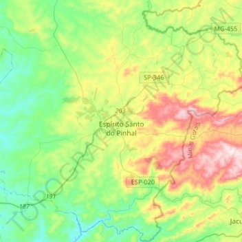
Name: Topografische Karte Espírito Santo do Pinhal, Höhe, Relief.
Durchschnittliche Höhe: 847 m
Minimale Höhe: 610 m
Maximale Höhe: 1.339 m
Andere topografische Karten
Klicken Sie auf eine Karte, um ihre Topografie, ihre Höhe und ihr Relief anzuzeigen.
São Paulo
Brazil > São Paulo > Região Metropolitana de São Paulo > São Paulo
São Paulo is in Southeastern Brazil, in southeastern São Paulo State, approximately halfway between Curitiba and Rio de Janeiro. The city is on a plateau placed beyond the Serra do Mar (Portuguese for "Sea Range" or "Coastal Range"), itself a component of the vast region known as the Brazilian Highlands,…
Durchschnittliche Höhe: 785 m
Ilha Sumítica
Brazil > São Paulo > Região Metropolitana do Vale do Paraíba e Litoral Norte > Ilhabela
Durchschnittliche Höhe: 1 m
Ilha Sumítica
Brazil > São Paulo > Região Metropolitana do Vale do Paraíba e Litoral Norte > Ilhabela
Durchschnittliche Höhe: 1 m
Morro do Diabo
Brazil > São Paulo > Teodoro Sampaio
Its summit altitude is 650 metres (2,130 ft) (ASL). Morro do Diabo is an area landmark, seen from the valleys and plains below it. It is located near the cities of Caxias do Sul and Porto Alegre, the state capital.
Durchschnittliche Höhe: 397 m
Sitio Borda da Mata
Brazil > São Paulo > Região Metropolitana de São Paulo > Franco da Rocha
Durchschnittliche Höhe: 793 m
Praça Bartolomeu de Messina
Brazil > São Paulo > Região Metropolitana de São Paulo > São Paulo
Durchschnittliche Höhe: 790 m
Mirante Rio Piracicaba
Brazil > São Paulo > Região Metropolitana de Piracicaba > Piracicaba
Durchschnittliche Höhe: 505 m
Paiol Grande
Brazil > São Paulo > Região Metropolitana do Vale do Paraíba e Litoral Norte > São Bento do Sapucaí
Durchschnittliche Höhe: 1.339 m
Texas
Brazil > São Paulo > Região Metropolitana de São Paulo > São Paulo
Durchschnittliche Höhe: 834 m
Mogi Mirim
Brazil > São Paulo > Mogi Mirim
Mogi Mirim is a municipality located in the eastern part of São Paulo State, in Brazil. The population is 93,650 (2020 est.) in an area of 498 km². The elevation is 611 m.
Durchschnittliche Höhe: 655 m
Rio Paraíba do Sul
Brazil > São Paulo > Região Metropolitana do Vale do Paraíba e Litoral Norte > Guaratinguetá
Durchschnittliche Höhe: 546 m
São Bernardo do Campo
Brazil > São Paulo > Região Metropolitana de São Paulo > São Bernardo do Campo
Durchschnittliche Höhe: 760 m
São José dos Campos
Brazil > São Paulo > Região Metropolitana do Vale do Paraíba e Litoral Norte
In the urban area, there are rolling plateaus and hills. The lowest elevation in the city (and also in the municipality) is found in the Paraíba do Sul River, at a mean elevation of 550 m.
Durchschnittliche Höhe: 634 m
Santo André
Brazil > São Paulo > Região Metropolitana de São Paulo > Santo André
Durchschnittliche Höhe: 776 m
Bairro Planalto do Sul
Brazil > São Paulo > Mirante do Paranapanema > Bairro Planalto do Sul
Durchschnittliche Höhe: 437 m
Sorocaba
Brazil > São Paulo > Região Metropolitana de Sorocaba > Sorocaba
The terrain is classified as a wavy strands and characterized by local ridges, with an average altitude of 632 meters above the sea level. The highest altitude is 1028 meters, in the Serra de Sao Francisco. The lower altitude is 539 meters, in the valley of the Sorocaba River. Sorocaba is located on the edge…
Durchschnittliche Höhe: 662 m