Geolokalisieren

Topografische Karte Hammond

Interaktive Karte

Klicken Sie auf die Karte, um die Höhe anzuzeigen.

Über diese Karte

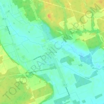
Name: Topografische Karte Hammond, Höhe, Relief.

Ort: Hammond, Clarence-Rockland, Prescott and Russell Counties, Eastern Ontario, Ontario, K0A 2A0, Canada (45.42158 -75.25994 45.46158 -75.21994)

Durchschnittliche Höhe: 71 m

Minimale Höhe: 59 m

Maximale Höhe: 88 m

Andere topografische Karten

Klicken Sie auf eine Karte, um ihre Topografie, ihre Höhe und ihr Relief anzuzeigen.

Clarence Creek

Canada > Ontario > Prescott and Russell Counties > Clarence-Rockland > Clarence Creek

Clarence Creek, Clarence-Rockland, Prescott and Russell Counties, Eastern Ontario, Ontario, K0A 1N0, Canada

Durchschnittliche Höhe: 66 m

Clarence Point

Canada > Ontario > Prescott and Russell Counties > Clarence-Rockland > Clarence Point

Clarence Point, Clarence-Rockland, Prescott and Russell Counties, Eastern Ontario, Ontario, K4K 1T2, Canada

Durchschnittliche Höhe: 61 m

Bourget

Canada > Ontario > Prescott and Russell Counties > Clarence-Rockland

Bourget, Clarence-Rockland, Prescott and Russell Counties, Eastern Ontario, Ontario, K0A 1E0, Canada

Durchschnittliche Höhe: 62 m