
Topografische Karte Major Island
Interaktive Karte
Klicken Sie auf die Karte, um die Höhe anzuzeigen.
Über diese Karte
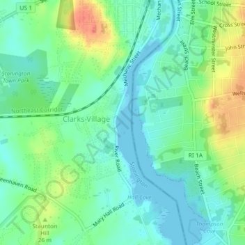
Name: Topografische Karte Major Island, Höhe, Relief.
Ort: Major Island, New London County, Connecticut, USA (41.35966 -71.83946 41.36025 -71.83902)
Durchschnittliche Höhe: 16 m
Minimale Höhe: -2 m
Maximale Höhe: 48 m
Andere topografische Karten
Klicken Sie auf eine Karte, um ihre Topografie, ihre Höhe und ihr Relief anzuzeigen.
Terramuggus
USA > Connecticut > Terramuggus
Terramuggus, Keirstead Circle, Terramuggus, Hartford County, Connecticut, 06447, USA
Durchschnittliche Höhe: 150 m
The Plans
USA > Connecticut > Norwalk
The Plans, Norwalk, Fairfield, Connecticut, USA
Durchschnittliche Höhe: 0 m
Gilbert Hill
Gilbert Hill, Fairfield, Connecticut, 06829, USA
Durchschnittliche Höhe: 152 m