
Topografische Karte Indian Cave State Park
Interaktive Karte
Klicken Sie auf die Karte, um die Höhe anzuzeigen.
Über diese Karte
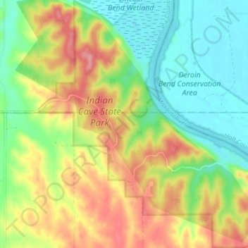
Name: Topografische Karte Indian Cave State Park, Höhe, Relief.
Ort: Indian Cave State Park, Richardson County, Nebraska, USA (40.23329 -95.58414 40.28522 -95.51668)
Durchschnittliche Höhe: 308 m
Minimale Höhe: 263 m
Maximale Höhe: 370 m
Andere topografische Karten
Klicken Sie auf eine Karte, um ihre Topografie, ihre Höhe und ihr Relief anzuzeigen.
Offutt Air Force Base
USA > Nebraska > Offutt Air Force Base
Offutt Air Force Base, Sarpy County, Nebraska, USA
Durchschnittliche Höhe: 307 m
Samuel R. McKelvie National Forest
Samuel R. McKelvie National Forest, Steer Creek Valley, Cherry County, Nebraska, USA
Durchschnittliche Höhe: 915 m
Fontenelle Forest Nature Center
Fontenelle Forest Nature Center, Sarpy County, Nebraska, USA
Durchschnittliche Höhe: 316 m
Boyer Chute National Wildlife Refuge
Boyer Chute National Wildlife Refuge, Washington County, Nebraska, USA
Durchschnittliche Höhe: 301 m
Gallagher Canyon State Recreation Area
Gallagher Canyon State Recreation Area, Dawson County, Nebraska, USA
Durchschnittliche Höhe: 812 m
Mormon Island
Mormon Island, Hall County, Nebraska, 68832, USA
Durchschnittliche Höhe: 578 m
North Twin Lake
North Twin Lake, Essie Road, Cherry County, Nebraska, USA
Durchschnittliche Höhe: 1.156 m
Lake Minatare
Lake Minatare, Scotts Bluff County, Nebraska, USA
Durchschnittliche Höhe: 1.262 m
Spring Creek Prairie Audubon
Spring Creek Prairie Audubon, Prairie Trail, Lancaster County, Nebraska, 68438, USA
Durchschnittliche Höhe: 425 m
Niobrara River
Niobrara River, Cherry County, Nebraska, 69201, USA
Durchschnittliche Höhe: 785 m
Rainwater Basin Wildlife Management District
Rainwater Basin Wildlife Management District, Stockham, Hamilton County, Nebraska, USA
Durchschnittliche Höhe: 529 m
Pawnee Lake
USA > Nebraska > Pawnee Village
Pawnee Lake, Road 2000, Pawnee Village, Webster County, Nebraska, 68942, USA
Durchschnittliche Höhe: 512 m
Wehrspann Lake
Wehrspann Lake, Wehrspann Lake Trail, Chalco, Sarpy County, Nebraska, 68136-1355, USA
Durchschnittliche Höhe: 351 m