Geolokalisieren

Topografische Karte Santa Ana

Interaktive Karte

Klicken Sie auf die Karte, um die Höhe anzuzeigen.

Über diese Karte

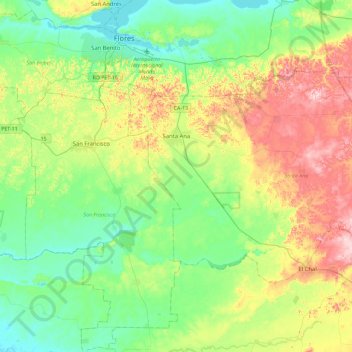
Name: Topografische Karte Santa Ana, Höhe, Relief.

Ort: Santa Ana, Petén, Guatemala (16.62389 -89.88674 16.89226 -89.42877)

Durchschnittliche Höhe: 202 m

Minimale Höhe: 105 m

Maximale Höhe: 402 m

Andere topografische Karten

Klicken Sie auf eine Karte, um ihre Topografie, ihre Höhe und ihr Relief anzuzeigen.

Tikal

Guatemala > Petén > Flores

Tikal, Tikal Road, Flores, Petén, Guatemala

Durchschnittliche Höhe: 270 m

Melchor de Mencos

Guatemala > Petén

Melchor de Mencos, Petén, 17011, Guatemala

Durchschnittliche Höhe: 236 m

El Chal

Guatemala > Petén

El Chal, Petén, Guatemala

Durchschnittliche Höhe: 280 m

Flores

Guatemala > Petén

Flores, Petén, Guatemala

Durchschnittliche Höhe: 210 m

Petén

Guatemala > Petén

Petén, Guatemala

Durchschnittliche Höhe: 207 m

Tikal

Guatemala > Petén > Flores > Zocotzal

Tikal, RD PET-03, Zocotzal, Flores, Petén, Guatemala

Durchschnittliche Höhe: 261 m

Nakbé

Guatemala > Petén > San José

Nakbé, San José, Petén, Guatemala

Durchschnittliche Höhe: 294 m

Río Holmul

Guatemala > Petén > Flores

Río Holmul, Flores, Petén, Guatemala

Durchschnittliche Höhe: 212 m

Naachtún

Guatemala > Petén > San José

Naachtún, San José, Petén, Guatemala

Durchschnittliche Höhe: 300 m

El Tintal

Guatemala > Petén > San Andrés

El Tintal, Calzada Maya from Tintal to El Mirador, San Andrés, Petén, Guatemala

Durchschnittliche Höhe: 245 m

Dolores

Guatemala > Petén

Dolores, Petén, Guatemala

Durchschnittliche Höhe: 402 m