
Topografische Karte Tokositna Glacier
Interaktive Karte
Klicken Sie auf die Karte, um die Höhe anzuzeigen.
Über diese Karte
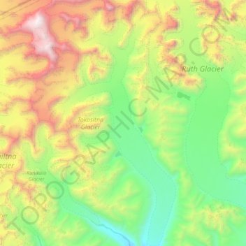
Name: Topografische Karte Tokositna Glacier, Höhe, Relief.
Ort: Tokositna Glacier, Matanuska-Susitna, Alaska, USA (62.67678 -151.10764 62.97728 -150.72351)
Durchschnittliche Höhe: 1.485 m
Minimale Höhe: 276 m
Maximale Höhe: 4.402 m
Andere topografische Karten
Klicken Sie auf eine Karte, um ihre Topografie, ihre Höhe und ihr Relief anzuzeigen.
Kuskulana Glacier
Kuskulana Glacier, Valdez-Cordova, Alaska, USA
Durchschnittliche Höhe: 2.337 m
Mendenhaven
USA > Alaska > Mendenhaven
Mendenhaven, Juneau, Alaska, 99801, USA
Durchschnittliche Höhe: 126 m
Kanikula Glacier
Kanikula Glacier, Matanuska-Susitna, Alaska, USA
Durchschnittliche Höhe: 1.606 m
Nabesna Glacier
Nabesna Glacier, Valdez-Cordova, Alaska, USA
Durchschnittliche Höhe: 2.224 m
Lacuna Glacier
Lacuna Glacier, Matanuska-Susitna, Alaska, USA
Durchschnittliche Höhe: 1.676 m
Yentna Glacier
Yentna Glacier, Matanuska-Susitna, Alaska, USA
Durchschnittliche Höhe: 1.529 m
Mount Alyeska
Mount Alyeska, Anchorage, Alaska, USA
Durchschnittliche Höhe: 712 m
Godwin Glacier
Godwin Glacier, Kenai Peninsula, Alaska, USA
Durchschnittliche Höhe: 1.023 m
Harvard Glacier
Harvard Glacier, Valdez-Cordova, Alaska, USA
Durchschnittliche Höhe: 1.914 m
Aleutian Islands
Aleutian Islands, Aleutians East, Alaska, USA
Durchschnittliche Höhe: 260 m
Worthington Glacier
Worthington Glacier, Richardson Highway, Ptarmigan, Valdez-Cordova, Alaska, USA
Durchschnittliche Höhe: 1.356 m
Baldwin Glacier
Baldwin Glacier, Valdez-Cordova, Alaska, USA
Durchschnittliche Höhe: 2.155 m
Chedotlothna Glacier
Chedotlothna Glacier, Denali, Alaska, USA
Durchschnittliche Höhe: 1.718 m
Byron Glacier
Byron Glacier, Byron Glacier Trail, Anchorage, Alaska, USA
Durchschnittliche Höhe: 749 m
Holgate Glacier
Holgate Glacier, Kenai Peninsula, Alaska, USA
Durchschnittliche Höhe: 1.020 m
Explorer Glacier
Explorer Glacier, Trail of Blue Ice, Anchorage, Alaska, USA
Durchschnittliche Höhe: 559 m
Natazhat Glacier
Natazhat Glacier, Valdez-Cordova, Alaska, USA
Durchschnittliche Höhe: 2.633 m
Exit Glacier
Exit Glacier, Harding Ice Field Approach Trail, Kenai Peninsula, Alaska, USA
Durchschnittliche Höhe: 1.092 m
Kuskokwim River
Kuskokwim River, Unorganized Borough, Alaska, USA
Durchschnittliche Höhe: 111 m
LeConte Glacier
LeConte Glacier, Petersburg Borough, Alaska, USA
Durchschnittliche Höhe: 407 m
Atka Island
Atka Island, Unorganized Borough, Alaska, 99547, USA
Durchschnittliche Höhe: 30 m
Aialik Glacier
Aialik Glacier, Kenai Peninsula, Alaska, USA
Durchschnittliche Höhe: 1.302 m
Cul-de-Sac Glacier
Cul-de-Sac Glacier, Matanuska-Susitna, Alaska, USA
Durchschnittliche Höhe: 1.541 m
Klutlan Glacier
Klutlan Glacier, Valdez-Cordova, Alaska, USA
Durchschnittliche Höhe: 2.515 m
Tazlina Glacier
Tazlina Glacier, Valdez-Cordova, Alaska, USA
Durchschnittliche Höhe: 1.474 m
Revillagigedo Island
Revillagigedo Island, Ketchikan Gateway, Alaska, USA
Durchschnittliche Höhe: 342 m
Admiralty Island
Admiralty Island, Hoonah-Angoon, Alaska, 99820, USA
Durchschnittliche Höhe: 295 m
Sargent Icefield
Sargent Icefield, Kenai Peninsula, Alaska, USA
Durchschnittliche Höhe: 817 m
Mount Cleveland
Mount Cleveland, Unorganized Borough, Alaska, USA
Durchschnittliche Höhe: 1.022 m
Island Glacier
Island Glacier, Lake and Peninsula, Alaska, USA
Durchschnittliche Höhe: 1.539 m
Variegated Glacier
Variegated Glacier, Yakutat, Alaska, USA
Durchschnittliche Höhe: 1.241 m
Straightaway Glacier
Straightaway Glacier, Denali, Alaska, USA
Durchschnittliche Höhe: 2.333 m