
Topografische Karte Valley of Flowers National Park
Interaktive Karte
Klicken Sie auf die Karte, um die Höhe anzuzeigen.
Über diese Karte
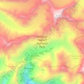
Name: Topografische Karte Valley of Flowers National Park, Höhe, Relief.
Durchschnittliche Höhe: 4.606 m
Minimale Höhe: 2.659 m
Maximale Höhe: 6.410 m
Andere topografische Karten
Klicken Sie auf eine Karte, um ihre Topografie, ihre Höhe und ihr Relief anzuzeigen.
Dadon
India > Uttarakhand > Joshimath Tehsil > Joshimath
Dadon, Joshimath, Joshimath Tehsil, Chamoli district, Uttarakhand, India
Durchschnittliche Höhe: 2.107 m
Pangarchulla
India > Uttarakhand > Joshimath Tehsil
Pangarchulla, Joshimath Tehsil, Chamoli District, Uttarakhand, 246483, India
Durchschnittliche Höhe: 4.061 m
Joshimath
India > Uttarakhand > Joshimath Tehsil
Joshimath, Joshimath Tehsil, Chamoli district, Uttarakhand, India
Durchschnittliche Höhe: 2.272 m
Nanda Devi
India > Uttarakhand > Joshimath Tehsil
Nanda Devi, Joshimath Tehsil, Chamoli District, Uttarakhand, India
Durchschnittliche Höhe: 6.567 m
Pinola
India > Uttarakhand > Joshimath Tehsil > Govindghat > Pinola
Pinola, Govindghat, Joshimath Tehsil, Chamoli district, Uttarakhand, India
Durchschnittliche Höhe: 2.454 m
Hemkund
India > Uttarakhand > Joshimath Tehsil
Hemkund, Joshimath Tehsil, Chamoli district, Uttarakhand, India
Durchschnittliche Höhe: 4.367 m
Badrinath
India > Uttarakhand > Joshimath Tehsil
Badrinath, Joshimath Tehsil, Chamoli District, Uttarakhand, India
Durchschnittliche Höhe: 4.052 m