
Topografische Karte Iroquois
Interaktive Karte
Klicken Sie auf die Karte, um die Höhe anzuzeigen.
Über diese Karte
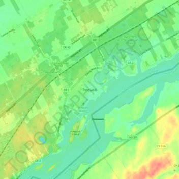
Name: Topografische Karte Iroquois, Höhe, Relief.
Durchschnittliche Höhe: 83 m
Minimale Höhe: 64 m
Maximale Höhe: 113 m
Andere topografische Karten
Klicken Sie auf eine Karte, um ihre Topografie, ihre Höhe und ihr Relief anzuzeigen.
Morrisburg
Canada > Ontario > Stormont, Dundas and Glengarry Counties > South Dundas
Morrisburg, South Dundas, Stormont, Dundas and Glengarry Counties, Eastern Ontario, Ontario, K0C 1X0, Canada
Durchschnittliche Höhe: 79 m
Macdonald Island
Canada > Ontario > Stormont, Dundas and Glengarry Counties > South Dundas
Macdonald Island, South Dundas, Stormont, Dundas and Glengarry Counties, Eastern Ontario, Ontario, Canada
Durchschnittliche Höhe: 75 m