
Topografische Karte Stupava
Interaktive Karte
Klicken Sie auf die Karte, um die Höhe anzuzeigen.
Über diese Karte
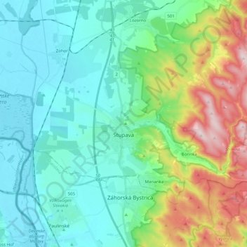
Name: Topografische Karte Stupava, Höhe, Relief.
Durchschnittliche Höhe: 237 m
Minimale Höhe: 137 m
Maximale Höhe: 540 m
The town is located in the Záhorie lowland, under the Little Carpathians, around 15 km (9 mi) north of Bratislava at an altitude of 182 metres. It has 15, 095 inhabitants as of 2021 and has a land area of 67.17 km2 (26 sq mi). Apart from the core part of the city, Mást (German: Maaßt, Hungarian: Mászt), located just south of the core part of the city, is another part of Stupava. It has been initially a separate village with ethnic Croatian majority, which was formally annexed by Stupava in 1953.
Andere topografische Karten
Klicken Sie auf eine Karte, um ihre Topografie, ihre Höhe und ihr Relief anzuzeigen.
Marianka
Slovakia > Region of Bratislava > District of Malacky
Marianka, District of Malacky, Region of Bratislava, 900 33, Slovakia
Durchschnittliche Höhe: 249 m
Kuchyňa
Slovakia > Region of Bratislava > District of Malacky
Kuchyňa, District of Malacky, Region of Bratislava, 900 52, Slovakia
Durchschnittliche Höhe: 319 m
Malacky
Slovakia > Region of Bratislava > District of Malacky
Malacky, District of Malacky, Region of Bratislava, Slovakia
Durchschnittliche Höhe: 168 m
Borinka
Slovakia > Region of Bratislava > District of Malacky > Borinka
Borinka, District of Malacky, Region of Bratislava, Slovakia
Durchschnittliche Höhe: 304 m