Geolokalisieren
👉 Easily get elevation data in JSON, GeoTIFF and KML formats using Elevation API
Vielen Dank für die Unterstützung dieser Website ❤️
Spenden

Rüsten Sie sich für Ihr nächstes Abenteuer:

Als Amazon-Partner erhält diese Website eine Provision für qualifizierte Käufe, ohne zusätzliche Kosten für Sie.

Topografische Karte Siddipet

Klicken Sie auf die Karte, um die Höhe anzuzeigen.

👉 Easily get elevation data in JSON, GeoTIFF and KML formats using Elevation API
Vielen Dank für die Unterstützung dieser Website ❤️
Spenden

Rüsten Sie sich für Ihr nächstes Abenteuer:

Als Amazon-Partner erhält diese Website eine Provision für qualifizierte Käufe, ohne zusätzliche Kosten für Sie.

Über diese Karte

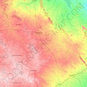
Name: Topografische Karte Siddipet, Höhe, Relief.

Ort: Siddipet, Telangana, India (17.66727 78.49290 18.34438 79.30336)

Durchschnittliche Höhe: 451 m

Minimale Höhe: 242 m

Maximale Höhe: 641 m

Andere topografische Karten

Klicken Sie auf eine Karte, um ihre Topografie, ihre Höhe und ihr Relief anzuzeigen.

Khammam

India > Telangana > Khammam Urban mandal

Khammam is located at 17°15′N 80°09′E / 17.25°N 80.15°E / 17.25; 80.15. It has an average elevation of 108 metres (390 feet).

Durchschnittliche Höhe: 130 m

Shamshabad

India > Telangana

Durchschnittliche Höhe: 574 m

Yeliminedu

India > Telangana > Ibrahimpatnam mandal

Durchschnittliche Höhe: 560 m

Sadasivpet

India > Telangana > Sadasivpet mandal

Sadashivpet is located at 17°37′00″N 77°57′00″E / 17.6167°N 77.9500°E / 17.6167; 77.9500. It has an average elevation of 534 meters (1755 feet). From Sadashivpet to Hyderabad 65 km, Vikarabad 36 km, Sadashivpet Road Railway Station 18 km, Bidar 69 km, Zahirabad 36 km, Gulbarga 154 km, SangaReddy 20 km.

Durchschnittliche Höhe: 538 m

Vielen Dank für die Unterstützung dieser Website ❤️
Spenden

Penuballi

India > Telangana > Penuballi mandal

Durchschnittliche Höhe: 131 m

Karimnagar

India > Telangana > Karimnagar mandal

Durchschnittliche Höhe: 286 m

Secunderabad

India > Telangana

Situated in the North of Hyderabad at 17°27′N 78°30′E / 17.45°N 78.5°E / 17.45; 78.5., Secunderabad lies on the northern part of the Deccan Plateau. Secunderabad has an average elevation of 543 metres (1781 ft). Most of the area has a rocky terrain and some areas are hilly.

Durchschnittliche Höhe: 544 m

Ponnal

India > Telangana

Durchschnittliche Höhe: 546 m

Athukur Thanda

India > Telangana

Durchschnittliche Höhe: 576 m

Kothwalguda

India > Telangana

Durchschnittliche Höhe: 549 m

Kamathwada

India > Telangana

Durchschnittliche Höhe: 249 m

Jamini

India > Telangana

Durchschnittliche Höhe: 304 m

Bodakonda

India > Telangana

Durchschnittliche Höhe: 539 m

Lalgadi Malakpet

India > Telangana

Durchschnittliche Höhe: 553 m

Saddupally

India > Telangana

Durchschnittliche Höhe: 476 m

Damergidda

India > Telangana

Durchschnittliche Höhe: 646 m

Arutla

India > Telangana

Durchschnittliche Höhe: 589 m

Machapur

India > Telangana

Durchschnittliche Höhe: 466 m

Gorelli

India > Telangana

Durchschnittliche Höhe: 460 m

Turakapally

India > Telangana

Durchschnittliche Höhe: 583 m

Mudimiyal

India > Telangana

Durchschnittliche Höhe: 612 m

Chennaraopet

India > Telangana > Chennaraopet mandal

Durchschnittliche Höhe: 227 m

Sarapaka

India > Telangana > Burgampadu mandal

Durchschnittliche Höhe: 55 m

Cherial

India > Telangana > Cherial mandal

Durchschnittliche Höhe: 480 m

Vielen Dank für die Unterstützung dieser Website ❤️
Spenden

Rüsten Sie sich für Ihr nächstes Abenteuer:

Als Amazon-Partner erhält diese Website eine Provision für qualifizierte Käufe, ohne zusätzliche Kosten für Sie.

Deccan Plateau

India > Telangana > Yedapally mandal

Durchschnittliche Höhe: 393 m

Gangaram

India > Telangana > Bijinapalle mandal

Durchschnittliche Höhe: 508 m

Narayanpet

India > Telangana > Narayanpet mandal

Durchschnittliche Höhe: 448 m

Dhanwada

India > Telangana > Dhanwada mandal

Durchschnittliche Höhe: 403 m

Marikal

India > Telangana > Marikal mandal

Durchschnittliche Höhe: 390 m

Makhtal

India > Telangana > Makthal mandal

Durchschnittliche Höhe: 366 m

Atmakur

India > Telangana > Atmakur mandal

Durchschnittliche Höhe: 236 m

Peddapendyala

India > Telangana > Dharmasagar mandal

Durchschnittliche Höhe: 326 m

Ippagudem

India > Telangana > Ghanpur (Stn) mandal

Durchschnittliche Höhe: 332 m

Warangal

India > Telangana > Warangal mandal

Warangal is located at 18°00′N 79°35′E / 18.0°N 79.58°E / 18.0; 79.58. It has an average elevation of 266 metres (873 feet). It is settled in the eastern part of Deccan Plateau made up of granite rocks and hill formations which left the region barren making the cultivation dependent on…

Durchschnittliche Höhe: 268 m

Kothagudem

India > Telangana > Kothagudem mandal

Kothagudem is located at 17°33′00″N 80°37′05″E / 17.55°N 80.618°E / 17.55; 80.618. It has an average elevation of 89 metres (295 ft) above sea level. The North of Kothagudem borders Chhattisgarh state which is approximately 120 km from the town.

Durchschnittliche Höhe: 109 m

Mancherial

India > Telangana > Mancherial mandal > Mancherial

Durchschnittliche Höhe: 152 m

Machapur

India > Telangana > Govindaraopet mandal

Durchschnittliche Höhe: 191 m

Lingagudem

India > Telangana > Penuballi mandal

Durchschnittliche Höhe: 145 m

Palwancha

India > Telangana > Palvancha mandal

Durchschnittliche Höhe: 112 m

Godamguda

India > Telangana > Vikarabad mandal

Durchschnittliche Höhe: 609 m

Vielen Dank für die Unterstützung dieser Website ❤️
Spenden

Rüsten Sie sich für Ihr nächstes Abenteuer:

Als Amazon-Partner erhält diese Website eine Provision für qualifizierte Käufe, ohne zusätzliche Kosten für Sie.

Jansi Nagar

India > Telangana > Khila Warangal mandal > Thimmapur

Durchschnittliche Höhe: 285 m

Sangareddy

India > Telangana > Sangareddy mandal

Durchschnittliche Höhe: 517 m

KCR Nagar

India > Telangana > Mahabubnagar_Urban mandal

Durchschnittliche Höhe: 529 m

Shadnagar

India > Telangana > Farooqnagar mandal

Durchschnittliche Höhe: 632 m

Quthbullapur

India > Telangana > Pudur mandal

Durchschnittliche Höhe: 618 m

Mokila

India > Telangana > Shankarpalle mandal

Durchschnittliche Höhe: 569 m

Pedda Cheruvu

India > Telangana > Hyderabad

Durchschnittliche Höhe: 550 m

Mamidipalle

India > Telangana > Kandi mandal

Durchschnittliche Höhe: 525 m

Tupranpet

India > Telangana > Choutuppal mandal

Durchschnittliche Höhe: 438 m

Banjaragadda Thanda

India > Telangana > Kandukur mandal

Durchschnittliche Höhe: 657 m

Kokkonda

India > Telangana > Mulug mandal

Durchschnittliche Höhe: 592 m

Kothur

India > Telangana > Tadvai mandal

Durchschnittliche Höhe: 126 m

Vielen Dank für die Unterstützung dieser Website ❤️
Spenden

Mulugu

India > Telangana > Mulug mandal

Durchschnittliche Höhe: 597 m

Mahbubnagar

India > Telangana > Mahabubnagar_Urban mandal

Mahbub Nagar is located at 16°44′N 77°59′E / 16.73°N 77.98°E / 16.73; 77.98. It has an average elevation of 498 metres (1633 feet). The city of Mahbub Nagar is located at a distance of 98 km from Hyderabad 130 km from Kurnool and 105 km from Raichur.

Durchschnittliche Höhe: 509 m

Chittapur

India > Telangana > Valigonda mandal

Durchschnittliche Höhe: 292 m

Narsingi

India > Telangana > Papannapet mandal

Durchschnittliche Höhe: 455 m

Vielen Dank für die Unterstützung dieser Website ❤️
Spenden

Rüsten Sie sich für Ihr nächstes Abenteuer:

Als Amazon-Partner erhält diese Website eine Provision für qualifizierte Käufe, ohne zusätzliche Kosten für Sie.

Kothapet

India > Telangana > Khanapur mandal

Durchschnittliche Höhe: 237 m

Osman Sagar

India > Telangana > Gandipet mandal > Khanapur

Durchschnittliche Höhe: 549 m

Musi

India > Telangana > Hyderabad

Durchschnittliche Höhe: 522 m

Maidipally

India > Telangana > Metpalli mandal

Durchschnittliche Höhe: 323 m

Alwal Lake

India > Telangana > Hyderabad

Durchschnittliche Höhe: 576 m

Govindapuram

India > Telangana > Bonakal mandal

Durchschnittliche Höhe: 104 m

Ranjani Thanda

India > Telangana > Kubeer mandal

Durchschnittliche Höhe: 461 m

Mugiligundla

India > Telangana > Marpalle mandal

Durchschnittliche Höhe: 592 m

Devarampally

India > Telangana > Mominpet mandal

Durchschnittliche Höhe: 617 m

Kapra lake

India > Telangana > Hyderabad

Durchschnittliche Höhe: 557 m

Atevelle

India > Telangana > Medchal mandal

Durchschnittliche Höhe: 588 m

Chandur

India > Telangana > Chandur mandal

Chandur is located at 16°59′N 79°04′E / 16.98°N 79.06°E / 16.98; 79.06. It has an average elevation of 484 metres (1587 feet).

Durchschnittliche Höhe: 256 m

Vielen Dank für die Unterstützung dieser Website ❤️
Spenden

Rüsten Sie sich für Ihr nächstes Abenteuer:

Als Amazon-Partner erhält diese Website eine Provision für qualifizierte Käufe, ohne zusätzliche Kosten für Sie.

Metpalli

India > Telangana > Metpalli mandal

Durchschnittliche Höhe: 308 m

Mahboobnagar

India > Telangana > Raiparthy mandal

Durchschnittliche Höhe: 245 m

Mallyal

India > Telangana > Eturnagaram mandal

Durchschnittliche Höhe: 110 m

Mohanraopeta

India > Telangana > Korutla mandal

Durchschnittliche Höhe: 291 m

Vielen Dank für die Unterstützung dieser Website ❤️
Spenden

Kammar Palle

India > Telangana > Kammarpally mandal

Durchschnittliche Höhe: 340 m

Kothatarlapad

India > Telangana > Khanapur mandal

Durchschnittliche Höhe: 257 m

Jadi Malkapur

India > Telangana > Mogudampally mandal

Durchschnittliche Höhe: 605 m

Kalkoda

India > Telangana > Marpalle mandal

Kalkoda is located at 17°28′31″N 77°43′34″E / 17.475388°N 77.726030°E / 17.475388; 77.726030. It has an average elevation of 617 metres (2027 ft).

Durchschnittliche Höhe: 590 m

Vielen Dank für die Unterstützung dieser Website ❤️
Spenden

Rüsten Sie sich für Ihr nächstes Abenteuer:

Als Amazon-Partner erhält diese Website eine Provision für qualifizierte Käufe, ohne zusätzliche Kosten für Sie.

Raghunadhapalem

India > Telangana > Karakagudem mandal

Durchschnittliche Höhe: 143 m

Musi River

India > Telangana > Hyderabad

Durchschnittliche Höhe: 490 m

Choutuppal

India > Telangana > Choutuppal mandal

Durchschnittliche Höhe: 375 m

Medipally

India > Telangana > Yacharam mandal

Durchschnittliche Höhe: 585 m

Vielen Dank für die Unterstützung dieser Website ❤️
Spenden

Peddavangara

India > Telangana > Peddavangara mandal

Durchschnittliche Höhe: 246 m

Kaddam

India > Telangana > Kaddampeddur mandal > Pandwapur

Durchschnittliche Höhe: 246 m

Kompally

India > Telangana > Papannapet mandal

Durchschnittliche Höhe: 435 m

Gopanpalle

India > Telangana > Tandur mandal

Durchschnittliche Höhe: 448 m

Geological Survey of India

India > Telangana > Hyderabad

Durchschnittliche Höhe: 502 m

Chaudur

India > Telangana > Nawabpet mandal

Durchschnittliche Höhe: 616 m

Maryapur

India > Telangana > Shabad mandal

Durchschnittliche Höhe: 644 m

Perapalla

India > Telangana > Narayanpet mandal

Durchschnittliche Höhe: 475 m

Kazipet

India > Telangana > Khaazipet mandal

Durchschnittliche Höhe: 286 m

Anthireddyguda

India > Telangana > Shabad mandal

Durchschnittliche Höhe: 595 m

Naglur

India > Telangana > Naglur

Durchschnittliche Höhe: 600 m

Komati Cheruvu

India > Telangana > Siddipet

Durchschnittliche Höhe: 489 m

Vielen Dank für die Unterstützung dieser Website ❤️
Spenden

Nagasamundar

India > Telangana > Nagasamundar

Durchschnittliche Höhe: 471 m

Bhoodan Pochampally

India > Telangana > B. Pochampally mandal

Durchschnittliche Höhe: 393 m

Himayath Sagar

India > Telangana > Gandipet mandal

Durchschnittliche Höhe: 538 m

Masaipet

India > Telangana > Masaipet

Durchschnittliche Höhe: 238 m

Vielen Dank für die Unterstützung dieser Website ❤️
Spenden

Masaipet

India > Telangana > Masaipet

Durchschnittliche Höhe: 519 m

Bejjur

India > Telangana > Bejjur

Durchschnittliche Höhe: 139 m

Rajaneli

India > Telangana > Rajaneli

Durchschnittliche Höhe: 629 m

Mucherla

India > Telangana > Mucherla

Durchschnittliche Höhe: 153 m

Rüsten Sie sich für Ihr nächstes Abenteuer:

🧊Kühltaschen - Hält Proviant und Getränke bei Sommerhitze frisch
🏔️Barometrische Höhenmesser - Präzise Höhenbestimmung unabhängig von GPS-Signalen
🔭Leichte Reisestative - Stabile Basis für Fotos und Spektive bei geringem Gewicht
💧Wasseraufbereitung - Chemische Reinigung von Trinkwasser für Notfälle
🔥Camping Grill Set - Grillset für Outdoor Küche

Als Amazon-Partner erhält diese Website eine Provision für qualifizierte Käufe, ohne zusätzliche Kosten für Sie.