
Spenden
Rüsten Sie sich für Ihr nächstes Abenteuer:
Als Amazon-Partner erhält diese Website eine Provision für qualifizierte Käufe, ohne zusätzliche Kosten für Sie.
Topografische Karte Mount Hayfield
Klicken Sie auf die Karte, um die Höhe anzuzeigen.
Spenden
Rüsten Sie sich für Ihr nächstes Abenteuer:
Als Amazon-Partner erhält diese Website eine Provision für qualifizierte Käufe, ohne zusätzliche Kosten für Sie.
Über diese Karte
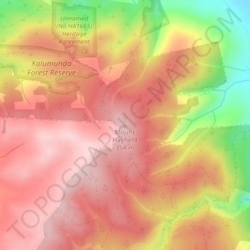
Name: Topografische Karte Mount Hayfield, Höhe, Relief.
Durchschnittliche Höhe: 278 m
Minimale Höhe: 113 m
Maximale Höhe: 364 m
Spenden
Rüsten Sie sich für Ihr nächstes Abenteuer:
Als Amazon-Partner erhält diese Website eine Provision für qualifizierte Käufe, ohne zusätzliche Kosten für Sie.
Andere topografische Karten
Klicken Sie auf eine Karte, um ihre Topografie, ihre Höhe und ihr Relief anzuzeigen.
Wirrina Cove
Australia > South Australia > The District Council of Yankalilla
Durchschnittliche Höhe: 43 m
Inman Valley
Australia > South Australia > The District Council of Yankalilla
In the valley is Selwyn Rock (35°29′47″S 138°30′45″E / 35.4965°S 138.5124°E / -35.4965; 138.5124) a glaciated pavement in the bed of the Inman River. It was first described in 1859 by, and later named for, A.R.C. Selwyn,[17] who was Victorian Government geologist at the time. Glacial…
Durchschnittliche Höhe: 212 m
Bald Hills
Australia > South Australia > The District Council of Yankalilla
Durchschnittliche Höhe: 162 m
Deep Creek National Park
Australia > South Australia > The District Council of Yankalilla
Durchschnittliche Höhe: 183 m
Spenden
Rüsten Sie sich für Ihr nächstes Abenteuer:
Als Amazon-Partner erhält diese Website eine Provision für qualifizierte Käufe, ohne zusätzliche Kosten für Sie.
Myponga
Australia > South Australia > The District Council of Yankalilla
Durchschnittliche Höhe: 246 m
Normanville
Australia > South Australia > The District Council of Yankalilla
Durchschnittliche Höhe: 64 m
Yankalilla
Australia > South Australia > The District Council of Yankalilla
Durchschnittliche Höhe: 104 m
Rapid Bay
Australia > South Australia > The District Council of Yankalilla
Durchschnittliche Höhe: 104 m
Spenden
Rüsten Sie sich für Ihr nächstes Abenteuer:
Als Amazon-Partner erhält diese Website eine Provision für qualifizierte Käufe, ohne zusätzliche Kosten für Sie.
Myponga River
Australia > South Australia > The District Council of Yankalilla > Myponga > Myponga Beach
Durchschnittliche Höhe: 138 m
Kalumunda Forest Reserve
Australia > South Australia > The District Council of Yankalilla
Durchschnittliche Höhe: 265 m
Myponga Beach
Australia > South Australia > The District Council of Yankalilla
Durchschnittliche Höhe: 110 m
Delamere
Australia > South Australia > The District Council of Yankalilla
Durchschnittliche Höhe: 253 m
Spenden
Rüsten Sie sich für Ihr nächstes Abenteuer:
Als Amazon-Partner erhält diese Website eine Provision für qualifizierte Käufe, ohne zusätzliche Kosten für Sie.
Cape Jervis
Australia > South Australia > The District Council of Yankalilla
Durchschnittliche Höhe: 73 m
Cape Jervis
Australia > South Australia > The District Council of Yankalilla
Durchschnittliche Höhe: 73 m
Delamere
Australia > South Australia > The District Council of Yankalilla
Durchschnittliche Höhe: 253 m
Spenden
Rüsten Sie sich für Ihr nächstes Abenteuer:
Als Amazon-Partner erhält diese Website eine Provision für qualifizierte Käufe, ohne zusätzliche Kosten für Sie.
Inman Valley
Australia > South Australia > The District Council of Yankalilla
In the valley is Selwyn Rock (35°29′47″S 138°30′45″E / 35.4965°S 138.5124°E / -35.4965; 138.5124) a glaciated pavement in the bed of the Inman River. It was first described in 1859 by, and later named for, A.R.C. Selwyn, who was Victorian Government geologist at the time. Glacial grooves…
Durchschnittliche Höhe: 212 m
Normanville
Australia > South Australia > The District Council of Yankalilla
Durchschnittliche Höhe: 64 m