
Topografische Karte Jones County
Interaktive Karte
Klicken Sie auf die Karte, um die Höhe anzuzeigen.
Über diese Karte
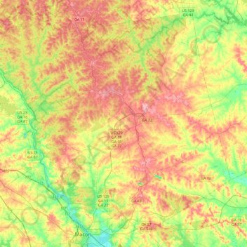
Name: Topografische Karte Jones County, Höhe, Relief.
Ort: Jones County, Georgia, USA (32.84129 -83.81653 33.18584 -83.35769)
Durchschnittliche Höhe: 145 m
Minimale Höhe: 81 m
Maximale Höhe: 212 m
Andere topografische Karten
Klicken Sie auf eine Karte, um ihre Topografie, ihre Höhe und ihr Relief anzuzeigen.
Ocoee River
Ocoee River, Fannin County, Georgia, 03513, USA
Durchschnittliche Höhe: 579 m
Ferrell Crossroads
USA > Georgia > Ferrell Crossroads
Ferrell Crossroads, Early County, Georgia, USA
Durchschnittliche Höhe: 94 m
Hidden Creek
Hidden Creek, Douglas County, Georgia, 30135, USA
Durchschnittliche Höhe: 286 m
Laurel Island
Laurel Island, Camden County, Georgia, 31547, USA
Durchschnittliche Höhe: 4 m
Cameron Point
USA > Georgia > Cameron Point
Cameron Point, Hall County, Georgia, 30506:30534, USA
Durchschnittliche Höhe: 339 m