
Topografische Karte Door County
Interaktive Karte
Klicken Sie auf die Karte, um die Höhe anzuzeigen.
Über diese Karte
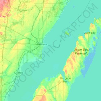
Name: Topografische Karte Door County, Höhe, Relief.
Ort: Door County, Wisconsin, United States of America (44.67496 -87.73686 45.42985 -86.76396)
Durchschnittliche Höhe: 191 m
Minimale Höhe: 172 m
Maximale Höhe: 315 m
The 102 ft high Brussels Hill (44°45′06″N 87°35′27″W / 44.75166°N 87.59093°W / 44.75166; -87.59093 (Brussels Hill), elevation 851 feet) is the highest point in the county. The nearby Red Hill Woods is the largest remaining maple–beech forest in the area.
Andere topografische Karten
Klicken Sie auf eine Karte, um ihre Topografie, ihre Höhe und ihr Relief anzuzeigen.
Dunn County
United States of America > Wisconsin
Dunn County, Wisconsin, United States of America
Durchschnittliche Höhe: 309 m
Madison
United States of America > Wisconsin > Madison
Madison, Dane, Wisconsin, United States of America
Durchschnittliche Höhe: 283 m
Waunakee
United States of America > Wisconsin > Waunakee
Waunakee, Wisconsin, United States of America
Durchschnittliche Höhe: 286 m
Milwaukee County
United States of America > Wisconsin
Milwaukee County, Wisconsin, United States of America
Durchschnittliche Höhe: 186 m
City of Middleton
United States of America > Wisconsin > City of Middleton
City of Middleton, Dane County, Wisconsin, 53562, United States of America
Durchschnittliche Höhe: 290 m
Walworth County
United States of America > Wisconsin
Walworth County, Wisconsin, United States of America
Durchschnittliche Höhe: 282 m