
Topografische Karte Agra
Interaktive Karte
Klicken Sie auf die Karte, um die Höhe anzuzeigen.
Über diese Karte
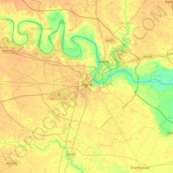
Name: Topografische Karte Agra, Höhe, Relief.
Ort: Agra, Uttar Pradesh, India (27.04720 77.85178 27.29598 78.22094)
Durchschnittliche Höhe: 166 m
Minimale Höhe: 143 m
Maximale Höhe: 181 m
The region around Agra consists almost entirely of a level plain, with hills in the extreme southwest. The rivers in the region include Yamuna and Chambal. The region is also watered by the Agra Canal. Millet, barley, wheat and cotton are among the crops grown in the surrounding countryside. Both Rabi and Kharif crops are cultivated. The deserted city of Fatehpur Sikri is about 40 km southwest of Agra. The sandstone hills near Fatehpur Sikri and on the south-eastern borders of the district are offshoots from the Vindhya range of Central India. Agra is about 210 km away from the National capital of New Delhi(via Yamuna Expressway), about 336 km from state capital Lucknow(via Agra-Lucknow Expressway), and about 227 km from Kanpur(via Agra-Lucknow Expressway). The city has an average elevation of 170 metres above sea level.
Andere topografische Karten
Klicken Sie auf eine Karte, um ihre Topografie, ihre Höhe und ihr Relief anzuzeigen.
Lucknow
India > Uttar Pradesh > Lucknow
Lucknow, Lucknow District, Uttar Pradesh, 226027, India
Durchschnittliche Höhe: 120 m
Faizabad
Faizabad, Ayodhya District, Uttar Pradesh, 224188, India
Durchschnittliche Höhe: 101 m
Shikarpur
Shikarpur, Bulandshahr District, Uttar Pradesh, India
Durchschnittliche Höhe: 195 m
Bilaspur
Bilaspur, Rampur District, Uttar Pradesh, India
Durchschnittliche Höhe: 195 m
Marihan
Marihan, Mirzapur, Uttar Pradesh, 231310, India
Durchschnittliche Höhe: 205 m
Nizamabad
Nizamabad, Azamgarh, Uttar Pradesh, 276305, India
Durchschnittliche Höhe: 81 m
Ghaziabad
India > Uttar Pradesh > Ghaziabad District
Ghaziabad, Ghaziabad District, Uttar Pradesh, India
Durchschnittliche Höhe: 213 m
Gairaha
India > Uttar Pradesh > Gairaha
Gairaha, Mauranipur, Jhansi, Uttar Pradesh, India
Durchschnittliche Höhe: 225 m
Beel Akbarpur
India > Uttar Pradesh > Beel Akbarpur
Beel Akbarpur, Ghaziabad, Uttar Pradesh, 201314, India
Durchschnittliche Höhe: 208 m
Balrampur
India > Uttar Pradesh > Balrampur
Balrampur, Uttar Pradesh, 271200, India
Durchschnittliche Höhe: 107 m
Kaushambi
India > Uttar Pradesh > Noida
Kaushambi, Noida, Ghaziabad, Uttar Pradesh, 201301, India
Durchschnittliche Höhe: 205 m
Mountains
Mountains, Kānpur, Kanpur Dehat, Uttar Pradesh, India
Durchschnittliche Höhe: 135 m
Morna
India > Uttar Pradesh > Morna
Morna, Ghaziabad, Uttar Pradesh, India
Durchschnittliche Höhe: 202 m
Sarnath
India > Uttar Pradesh > Sarnath
Sarnath, Vārānasi, Varanasi, Uttar Pradesh, 221007, India
Durchschnittliche Höhe: 78 m
Ganges
India > Uttar Pradesh > Ghazipur
Ganges, Ghazipur, Uttar Pradesh, 233001, India
Durchschnittliche Höhe: 1.626 m