
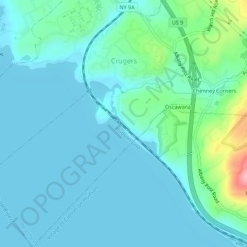
Topografische Karte Crugers
Interaktive Karte
Klicken Sie auf die Karte, um die Höhe anzuzeigen.
Über diese Karte
Name: Topografische Karte Crugers, Höhe, Relief.
Durchschnittliche Höhe: 23 m
Minimale Höhe: 0 m
Maximale Höhe: 144 m
Andere topografische Karten
Klicken Sie auf eine Karte, um ihre Topografie, ihre Höhe und ihr Relief anzuzeigen.
Crompond
United States > New York > Westchester County > Town of Cortlandt
Crompond, Town of Cortlandt, Westchester County, New York, 10517, United States
Durchschnittliche Höhe: 131 m
Roe Park
United States > New York > Westchester County > Town of Cortlandt
Roe Park, Town of Cortlandt, Westchester County, New York, 10567, United States
Durchschnittliche Höhe: 106 m
Pleasantside
United States > New York > Westchester County > Town of Cortlandt
Pleasantside, Town of Cortlandt, Westchester County, New York, 10567, United States
Durchschnittliche Höhe: 108 m
Village of Croton-on-Hudson
United States > New York > Westchester County > Town of Cortlandt
Village of Croton-on-Hudson, Town of Cortlandt, Westchester County, New York, 10520, United States
Durchschnittliche Höhe: 42 m
Village of Buchanan
United States > New York > Westchester County > Town of Cortlandt
Village of Buchanan, Town of Cortlandt, Westchester County, New York, 10511, United States
Durchschnittliche Höhe: 28 m
Toddville
United States > New York > Westchester County > Town of Cortlandt
Toddville, Town of Cortlandt, Westchester County, New York, 10567, United States
Durchschnittliche Höhe: 114 m