
Spenden
Rüsten Sie sich für Ihr nächstes Abenteuer:
Als Amazon-Partner erhält diese Website eine Provision für qualifizierte Käufe, ohne zusätzliche Kosten für Sie.
Topografische Karte Yorkville
Klicken Sie auf die Karte, um die Höhe anzuzeigen.
Spenden
Rüsten Sie sich für Ihr nächstes Abenteuer:
Als Amazon-Partner erhält diese Website eine Provision für qualifizierte Käufe, ohne zusätzliche Kosten für Sie.
Über diese Karte
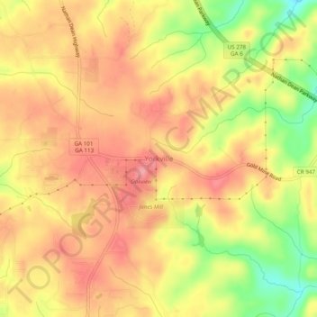
Name: Topografische Karte Yorkville, Höhe, Relief.
Ort: Yorkville, Paulding County, Georgia, 30153, United States (33.90350 -85.01136 33.94350 -84.97136)
Durchschnittliche Höhe: 393 m
Minimale Höhe: 340 m
Maximale Höhe: 426 m
Spenden
Rüsten Sie sich für Ihr nächstes Abenteuer:
Als Amazon-Partner erhält diese Website eine Provision für qualifizierte Käufe, ohne zusätzliche Kosten für Sie.
Andere topografische Karten
Klicken Sie auf eine Karte, um ihre Topografie, ihre Höhe und ihr Relief anzuzeigen.
Dallas
United States > Georgia > Paulding County
On April 4, 1977, near the site marker for the Battle of New Hope Church, the forced landing of Southern Airways Flight 242 occurred. The passenger jetliner, a McDonnell Douglas DC-9 with 81 passengers and 4 crew members, was flying from Northwest Alabama Regional Airport to Atlanta Municipal Airport. Upon…
Durchschnittliche Höhe: 307 m
Spenden
Rüsten Sie sich für Ihr nächstes Abenteuer:
Als Amazon-Partner erhält diese Website eine Provision für qualifizierte Käufe, ohne zusätzliche Kosten für Sie.
Dallas
United States > Georgia > Paulding County
On April 4, 1977, near the site marker for the Battle of New Hope Church, the forced landing of Southern Airways Flight 242 occurred. The passenger jetliner, a McDonnell Douglas DC-9 with 81 passengers and 4 crew members, was flying from Northwest Alabama Regional Airport to Atlanta Municipal Airport. Upon…
Durchschnittliche Höhe: 307 m