
Spenden
Rüsten Sie sich für Ihr nächstes Abenteuer:
Als Amazon-Partner erhält diese Website eine Provision für qualifizierte Käufe, ohne zusätzliche Kosten für Sie.
Topografische Karte Cabourg
Klicken Sie auf die Karte, um die Höhe anzuzeigen.
Spenden
Rüsten Sie sich für Ihr nächstes Abenteuer:
Als Amazon-Partner erhält diese Website eine Provision für qualifizierte Käufe, ohne zusätzliche Kosten für Sie.
Über diese Karte
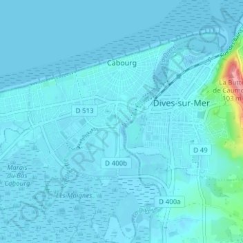
Name: Topografische Karte Cabourg, Höhe, Relief.
Durchschnittliche Höhe: 6 m
Minimale Höhe: -4 m
Maximale Höhe: 104 m
Spenden
Rüsten Sie sich für Ihr nächstes Abenteuer:
Als Amazon-Partner erhält diese Website eine Provision für qualifizierte Käufe, ohne zusätzliche Kosten für Sie.
Andere topografische Karten
Klicken Sie auf eine Karte, um ihre Topografie, ihre Höhe und ihr Relief anzuzeigen.
Place de l'Hôtel de Ville
France > Normandie > Calvados > Condé-en-Normandie
Durchschnittliche Höhe: 112 m
Quartier de l'Église
France > Normandie > Calvados > Livarot-Pays-d'Auge > Le Mesnil-Bacley
Durchschnittliche Höhe: 124 m
La Boudehannière
France > Normandie > Calvados > Dialan sur Chaîne > Jurques
Durchschnittliche Höhe: 210 m
Spenden
Rüsten Sie sich für Ihr nächstes Abenteuer:
Als Amazon-Partner erhält diese Website eine Provision für qualifizierte Käufe, ohne zusätzliche Kosten für Sie.
Manoir de la Morsanglière
France > Normandie > Calvados > Bonneville-la-Louvet
Durchschnittliche Höhe: 81 m
La Bajonière
France > Normandie > Calvados > Noues de Sienne > Mesnil-Clinchamps
Durchschnittliche Höhe: 169 m
Spenden
Rüsten Sie sich für Ihr nächstes Abenteuer:
Als Amazon-Partner erhält diese Website eine Provision für qualifizierte Käufe, ohne zusätzliche Kosten für Sie.
Spenden
Rüsten Sie sich für Ihr nächstes Abenteuer:
Als Amazon-Partner erhält diese Website eine Provision für qualifizierte Käufe, ohne zusätzliche Kosten für Sie.
Spenden
Rüsten Sie sich für Ihr nächstes Abenteuer:
Als Amazon-Partner erhält diese Website eine Provision für qualifizierte Käufe, ohne zusätzliche Kosten für Sie.
Le Val de May
France > Normandie > Calvados > Saint-Martin-de-May > May-sur-Orne
Durchschnittliche Höhe: 49 m
Secqueville
France > Normandie > Calvados > Le Castelet > Garcelles-Secqueville
Durchschnittliche Höhe: 65 m
Spenden
Rüsten Sie sich für Ihr nächstes Abenteuer:
Als Amazon-Partner erhält diese Website eine Provision für qualifizierte Käufe, ohne zusätzliche Kosten für Sie.
Spenden
Rüsten Sie sich für Ihr nächstes Abenteuer:
Als Amazon-Partner erhält diese Website eine Provision für qualifizierte Käufe, ohne zusätzliche Kosten für Sie.
Spenden
Rüsten Sie sich für Ihr nächstes Abenteuer:
Als Amazon-Partner erhält diese Website eine Provision für qualifizierte Käufe, ohne zusätzliche Kosten für Sie.
Le Moulin Pinel
France > Normandie > Calvados > Souleuvre-en-Bocage > Le Tourneur
Durchschnittliche Höhe: 169 m
Les Blanches Landes
France > Normandie > Calvados > Souleuvre-en-Bocage > Saint-Martin-des-Besaces
Durchschnittliche Höhe: 181 m
Spenden
Rüsten Sie sich für Ihr nächstes Abenteuer:
Als Amazon-Partner erhält diese Website eine Provision für qualifizierte Käufe, ohne zusätzliche Kosten für Sie.
Spenden
Rüsten Sie sich für Ihr nächstes Abenteuer:
Als Amazon-Partner erhält diese Website eine Provision für qualifizierte Käufe, ohne zusätzliche Kosten für Sie.
Spenden
Rüsten Sie sich für Ihr nächstes Abenteuer:
Als Amazon-Partner erhält diese Website eine Provision für qualifizierte Käufe, ohne zusätzliche Kosten für Sie.
Spenden
Rüsten Sie sich für Ihr nächstes Abenteuer:
Als Amazon-Partner erhält diese Website eine Provision für qualifizierte Käufe, ohne zusätzliche Kosten für Sie.
Hameau d'Aunay
France > Normandie > Calvados > Valdallière > Saint-Charles-de-Percy
Durchschnittliche Höhe: 163 m
Spenden
Rüsten Sie sich für Ihr nächstes Abenteuer:
Als Amazon-Partner erhält diese Website eine Provision für qualifizierte Käufe, ohne zusätzliche Kosten für Sie.
Spenden
Rüsten Sie sich für Ihr nächstes Abenteuer:
Als Amazon-Partner erhält diese Website eine Provision für qualifizierte Käufe, ohne zusätzliche Kosten für Sie.
Spenden
Rüsten Sie sich für Ihr nächstes Abenteuer:
Als Amazon-Partner erhält diese Website eine Provision für qualifizierte Käufe, ohne zusätzliche Kosten für Sie.
Spenden
Rüsten Sie sich für Ihr nächstes Abenteuer:
Als Amazon-Partner erhält diese Website eine Provision für qualifizierte Käufe, ohne zusätzliche Kosten für Sie.
Spenden
Rüsten Sie sich für Ihr nächstes Abenteuer:
Als Amazon-Partner erhält diese Website eine Provision für qualifizierte Käufe, ohne zusätzliche Kosten für Sie.
Saint-Martin-de-Blagny
France > Normandie > Calvados > Saint-Martin-de-Blagny > Saint-Martin-de-Blagny
Durchschnittliche Höhe: 41 m
Spenden
Rüsten Sie sich für Ihr nächstes Abenteuer:
Als Amazon-Partner erhält diese Website eine Provision für qualifizierte Käufe, ohne zusätzliche Kosten für Sie.
Les Châtaigniers
France > Normandie > Calvados > Saint-Philbert-des-Champs
Durchschnittliche Höhe: 140 m
Spenden
Rüsten Sie sich für Ihr nächstes Abenteuer:
Als Amazon-Partner erhält diese Website eine Provision für qualifizierte Käufe, ohne zusätzliche Kosten für Sie.
Colleville-Montgomery
France > Normandie > Calvados > Colleville-Montgomery > Colleville-Montgomery
Durchschnittliche Höhe: 20 m
Le Fresne-Camilly
France > Normandie > Calvados > Le Fresne-Camilly > Le Fresne-Camilly
Durchschnittliche Höhe: 47 m
Saint-Manvieu-Norrey
France > Normandie > Calvados > Saint-Manvieu-Norrey > Saint-Manvieu-Norrey
Durchschnittliche Höhe: 75 m
Spenden
Rüsten Sie sich für Ihr nächstes Abenteuer:
Als Amazon-Partner erhält diese Website eine Provision für qualifizierte Käufe, ohne zusätzliche Kosten für Sie.
Colombiers-sur-Seulles
France > Normandie > Calvados > Colombiers-sur-Seulles > Colombiers-sur-Seulles
Durchschnittliche Höhe: 37 m
Fontenay-le-Marmion
France > Normandie > Calvados > Fontenay-le-Marmion > Fontenay-le-Marmion
Durchschnittliche Höhe: 63 m
Spenden
Rüsten Sie sich für Ihr nächstes Abenteuer:
Als Amazon-Partner erhält diese Website eine Provision für qualifizierte Käufe, ohne zusätzliche Kosten für Sie.
Coquainvilliers
France > Normandie > Calvados > Coquainvilliers > Coquainvilliers
Durchschnittliche Höhe: 84 m
Les Monts d'Aunay
France > Normandie > Calvados > Les Monts d'Aunay > Les Monts d'Aunay
Durchschnittliche Höhe: 151 m
Fresney-le-Vieux
France > Normandie > Calvados > Fresney-le-Vieux > Fresney-le-Vieux
Durchschnittliche Höhe: 169 m
Spenden
Rüsten Sie sich für Ihr nächstes Abenteuer:
Als Amazon-Partner erhält diese Website eine Provision für qualifizierte Käufe, ohne zusätzliche Kosten für Sie.
La Pommeraye
France > Normandie > Calvados > La Pommeraye > La Pommeraye
Durchschnittliche Höhe: 188 m
Spenden
Rüsten Sie sich für Ihr nächstes Abenteuer:
Als Amazon-Partner erhält diese Website eine Provision für qualifizierte Käufe, ohne zusätzliche Kosten für Sie.
Saint-Aubin-d'Arquenay
France > Normandie > Calvados > Saint-Aubin-d'Arquenay > Saint-Aubin-d'Arquenay
Durchschnittliche Höhe: 23 m
Ouilly-le-Tesson
France > Normandie > Calvados > Ouilly-le-Tesson > Ouilly-le-Tesson
Durchschnittliche Höhe: 131 m
Spenden
Rüsten Sie sich für Ihr nächstes Abenteuer:
Als Amazon-Partner erhält diese Website eine Provision für qualifizierte Käufe, ohne zusätzliche Kosten für Sie.
Villers-Canivet
France > Normandie > Calvados > Villers-Canivet > Villers-Canivet
Durchschnittliche Höhe: 162 m
Juaye-Mondaye
France > Normandie > Calvados > Juaye-Mondaye > Juaye-Mondaye
Durchschnittliche Höhe: 81 m
Spenden
Rüsten Sie sich für Ihr nächstes Abenteuer:
Als Amazon-Partner erhält diese Website eine Provision für qualifizierte Käufe, ohne zusätzliche Kosten für Sie.
Spenden
Rüsten Sie sich für Ihr nächstes Abenteuer:
Als Amazon-Partner erhält diese Website eine Provision für qualifizierte Käufe, ohne zusätzliche Kosten für Sie.