
Topografische Karte Montana
Interaktive Karte
Klicken Sie auf die Karte, um die Höhe anzuzeigen.
Montana
The former municipality is located in the Sierre district, above the right bank of the Rhone. It consists of the villages of Montana and Corin, part of the Champzabé, the hamlet of Diogne as well as the resort of Montana-Vermala (located at an elevation of 1,500 m (4,900 ft) and shared between Montana and Randogne).
Über diese Karte
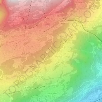
Name: Topografische Karte Montana, Höhe, Relief.
Ort: Montana, Crans-Montana, Sierre, Wallis, 3960, Switzerland (46.27903 7.47028 46.32009 7.51131)
Durchschnittliche Höhe: 1.231 m
Minimale Höhe: 515 m
Maximale Höhe: 1.839 m