
Topografische Karte Armadale
Interaktive Karte
Klicken Sie auf die Karte, um die Höhe anzuzeigen.
Armadale
Aside from the presence of the old castle, Armadale was little more than a rural farm community for most of its history, as part of a larger rural estate named Barbauchlaw (a corruption of 'Boar Baughlee'). However, this situation changed with the coming of the new turnpike road between Edinburgh and Glasgow in 1786, with Armadale having a location at a main highway junction on both the new regular east/west stagecoach route and also the old main north/south cattle droving route. This led to the establishment of a small village, including the establishment of a coaching inn (opening in 1797) and toll house. The toll house at Armadale was built where the new road intersected with an existing road in the east of the estate. The estate comprising the lands of Barbauchlaw was sold to Sir William Honeyman in 1790 and upon his elevation to the bench in 1797 he took the title of Lord Armadale (from his mother's estate in Sutherland) and this name was then applied to the township.
Über diese Karte
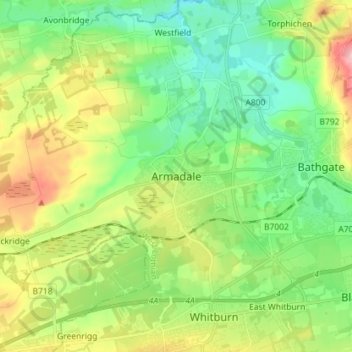
Name: Topografische Karte Armadale, Höhe, Relief.
Ort: Armadale, West Lothian, Scotland, EH48 3QB, United Kingdom (55.85877 -3.74020 55.93877 -3.66020)
Durchschnittliche Höhe: 166 m
Minimale Höhe: 101 m
Maximale Höhe: 293 m