
Topografische Karte Occidental Mindoro
Interaktive Karte
Klicken Sie auf die Karte, um die Höhe anzuzeigen.
Über diese Karte
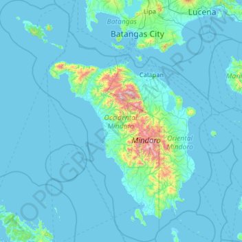
Name: Topografische Karte Occidental Mindoro, Höhe, Relief.
Ort: Occidental Mindoro, Mimaropa, Philippines (12.02089 119.87780 14.03724 121.24399)
Durchschnittliche Höhe: 90 m
Minimale Höhe: -2 m
Maximale Höhe: 2.505 m
Andere topografische Karten
Klicken Sie auf eine Karte, um ihre Topografie, ihre Höhe und ihr Relief anzuzeigen.
Rizal
Philippines > Occidental Mindoro
Rizal, Occidental Mindoro, Mimaropa, Philippines
Durchschnittliche Höhe: 4 m
Mindoro
Philippines > Occidental Mindoro
Mindoro, Sablayan, Occidental Mindoro, Mimaropa, 5104, Philippines
Durchschnittliche Höhe: 173 m