
Spenden
Rüsten Sie sich für Ihr nächstes Abenteuer:
Als Amazon-Partner erhält diese Website eine Provision für qualifizierte Käufe, ohne zusätzliche Kosten für Sie.
Topografische Karte East Cleveland
Klicken Sie auf die Karte, um die Höhe anzuzeigen.
Spenden
Rüsten Sie sich für Ihr nächstes Abenteuer:
Als Amazon-Partner erhält diese Website eine Provision für qualifizierte Käufe, ohne zusätzliche Kosten für Sie.
East Cleveland
Most of the city is located in a relatively flat and relatively lower area contiguous with the city of Cleveland. A small portion of the city lies atop a steep hill, and is contiguous with the neighboring city of Cleveland Heights; it also lies in a relatively flat area at a higher elevation. Superior Road, Forest Hills Boulevard, Lee Road, Noble and North Taylor roads are the major through-streets ascending the hill. The McGregor Home and the Forest Hill Historic District are located on "the hill."
Spenden
Rüsten Sie sich für Ihr nächstes Abenteuer:
Als Amazon-Partner erhält diese Website eine Provision für qualifizierte Käufe, ohne zusätzliche Kosten für Sie.
Über diese Karte
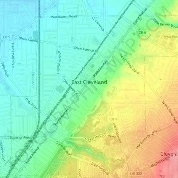
Name: Topografische Karte East Cleveland, Höhe, Relief.
Ort: East Cleveland, Cuyahoga County, Ohio, 44112, United States (41.51555 -81.59863 41.54806 -81.55545)
Durchschnittliche Höhe: 224 m
Minimale Höhe: 188 m
Maximale Höhe: 287 m
Spenden
Rüsten Sie sich für Ihr nächstes Abenteuer:
Als Amazon-Partner erhält diese Website eine Provision für qualifizierte Käufe, ohne zusätzliche Kosten für Sie.
Andere topografische Karten
Klicken Sie auf eine Karte, um ihre Topografie, ihre Höhe und ihr Relief anzuzeigen.
Cuyahoga River
United States > Ohio > Cuyahoga County > Cleveland
The upper Cuyahoga River, starting at 1,093 feet (333 m) over 84 miles (135 km) from its mouth, drops in elevation fairly steeply, creating falls and rapids in some places; the lower Cuyahoga River only drops several feet along the last several miles of the lower river to 571 feet (174 m) at the mouth on Lake…
Durchschnittliche Höhe: 196 m
Cleveland
United States > Ohio > Cuyahoga County > Cleveland
The land rises quickly from the lake shore elevation of 569 feet. Public Square, less than one mile (1.6 km) inland, sits at an elevation of 650 feet (198 m), and Hopkins Airport, 5 miles (8 km) inland from the lake, is at an elevation of 791 feet (241 m).
Durchschnittliche Höhe: 221 m
Spenden
Rüsten Sie sich für Ihr nächstes Abenteuer:
Als Amazon-Partner erhält diese Website eine Provision für qualifizierte Käufe, ohne zusätzliche Kosten für Sie.