
Topografische Karte All'Acqua
Interaktive Karte
Klicken Sie auf die Karte, um die Höhe anzuzeigen.
Über diese Karte
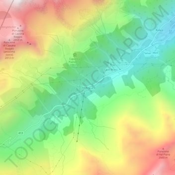
Name: Topografische Karte All'Acqua, Höhe, Relief.
Durchschnittliche Höhe: 2.033 m
Minimale Höhe: 1.402 m
Maximale Höhe: 2.923 m
Andere topografische Karten
Klicken Sie auf eine Karte, um ihre Topografie, ihre Höhe und ihr Relief anzuzeigen.
Corno Gries / Grieshorn
Suisse > Tessin > District de Léventine > Bedretto
Corno Gries / Grieshorn, Bedretto, Circolo di Airolo, District de Léventine, Tessin, 6781, Suisse
Durchschnittliche Höhe: 2.557 m
Capanna Corno Gries CAS
Suisse > Tessin > District de Léventine > Bedretto
Capanna Corno Gries CAS, gta, Corno, Bedretto, Circolo di Airolo, District de Léventine, Tessin, 6781, Suisse
Durchschnittliche Höhe: 2.417 m