
Topografische Karte Kefalonia
Interaktive Karte
Klicken Sie auf die Karte, um die Höhe anzuzeigen.
Über diese Karte
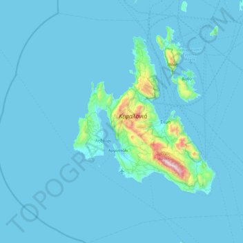
Name: Topografische Karte Kefalonia, Höhe, Relief.
Durchschnittliche Höhe: 60 m
Minimale Höhe: -1 m
Maximale Höhe: 1.601 m
Andere topografische Karten
Klicken Sie auf eine Karte, um ihre Topografie, ihre Höhe und ihr Relief anzuzeigen.
Cephalonia
Greece > Peloponnese, Western Greece and the Ionian > Kefallonia Regional Unit
Cephalonia, Kefallonia Regional Unit, Ioanian Islands, Peloponnese, Western Greece and the Ionian, Greece
Durchschnittliche Höhe: 138 m
Antipata
Greece > Peloponnese, Western Greece and the Ionian > Kefallonia Regional Unit > Pylaros Municipal Unit > Antipata
Antipata, Pylaros Municipal Unit, Sami Municipality, Kefallonia Regional Unit, Ioanian Islands, Peloponnese, Western Greece and the Ionian, 28081, Greece
Durchschnittliche Höhe: 387 m