
Topografische Karte Ingomar
Interaktive Karte
Klicken Sie auf die Karte, um die Höhe anzuzeigen.
Über diese Karte
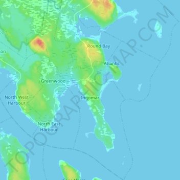
Name: Topografische Karte Ingomar, Höhe, Relief.
Durchschnittliche Höhe: 5 m
Minimale Höhe: -2 m
Maximale Höhe: 48 m
Andere topografische Karten
Klicken Sie auf eine Karte, um ihre Topografie, ihre Höhe und ihr Relief anzuzeigen.
Goose Lake
Canada > Nova Scotia > Shelburne County
Goose Lake, Municipality of the District of Barrington, Shelburne County, Nova Scotia, B0W 1E0, Canada
Durchschnittliche Höhe: 21 m
Town of Clark's Harbour
Canada > Nova Scotia > Shelburne County
Town of Clark's Harbour, Shelburne County, Nova Scotia, Canada
Durchschnittliche Höhe: 2 m
Town of Shelburne
Canada > Nova Scotia > Shelburne County
Town of Shelburne, Shelburne County, Nova Scotia, Canada
Durchschnittliche Höhe: 28 m
Stoney Island
Canada > Nova Scotia > Shelburne County
Stoney Island, Municipality of the District of Barrington, Shelburne County, Nova Scotia, B0W 1P0, Canada
Durchschnittliche Höhe: 3 m
Canada Hill
Canada > Nova Scotia > Shelburne County > Canada Hill
Canada Hill, Municipality of the District of Shelburne, Shelburne County, Nova Scotia, B0T 1L0, Canada
Durchschnittliche Höhe: 34 m
Churchover
Canada > Nova Scotia > Shelburne County
Churchover, Municipality of the District of Shelburne, Shelburne County, Nova Scotia, B0T 1W0, Canada
Durchschnittliche Höhe: 27 m
Shelburne
Canada > Nova Scotia > Shelburne County > Shelburne
Shelburne, Town of Shelburne, Shelburne County, Nova Scotia, Canada
Durchschnittliche Höhe: 28 m