
Topografische Karte Turnerville
Interaktive Karte
Klicken Sie auf die Karte, um die Höhe anzuzeigen.
Über diese Karte
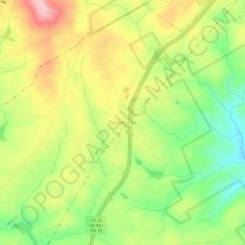
Name: Topografische Karte Turnerville, Höhe, Relief.
Ort: Turnerville, Habersham County, Georgia, 30580, United States (34.66676 -83.44600 34.70676 -83.40600)
Durchschnittliche Höhe: 463 m
Minimale Höhe: 371 m
Maximale Höhe: 564 m
Andere topografische Karten
Klicken Sie auf eine Karte, um ihre Topografie, ihre Höhe und ihr Relief anzuzeigen.
Tugaloo
United States > Georgia > Habersham County > Tallulah Falls
Tugaloo, Tallulah Falls, Habersham County, Georgia, United States
Durchschnittliche Höhe: 392 m
Habersham
United States > Georgia > Habersham County
Habersham, Habersham County, Georgia, 30544, United States
Durchschnittliche Höhe: 409 m
Baldwin
United States > Georgia > Habersham County
Baldwin, Habersham County, Georgia, United States
Durchschnittliche Höhe: 395 m
Clarkesville
United States > Georgia > Habersham County
Clarkesville, Habersham County, Georgia, United States
Durchschnittliche Höhe: 418 m
Mount Airy
United States > Georgia > Habersham County
Mount Airy, Habersham County, Georgia, United States
Durchschnittliche Höhe: 443 m
Demorest
United States > Georgia > Habersham County
Demorest, Habersham County, Georgia, United States
Durchschnittliche Höhe: 416 m
Apple Pie Mountain
United States > Georgia > Habersham County
Apple Pie Mountain, Habersham County, Georgia, 30573, United States
Durchschnittliche Höhe: 537 m
Cornelia
United States > Georgia > Habersham County
Cornelia, Habersham County, Georgia, United States
Durchschnittliche Höhe: 446 m
Tallulah Falls
United States > Georgia > Habersham County
Tallulah Falls, Habersham County, Georgia, United States
Durchschnittliche Höhe: 488 m