
Topografische Karte Horry County
Interaktive Karte
Klicken Sie auf die Karte, um die Höhe anzuzeigen.
Über diese Karte
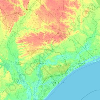
Name: Topografische Karte Horry County, Höhe, Relief.
Ort: Horry County, South Carolina, United States (33.56912 -79.33546 34.29963 -78.54135)
Durchschnittliche Höhe: 14 m
Minimale Höhe: -5 m
Maximale Höhe: 40 m
Andere topografische Karten
Klicken Sie auf eine Karte, um ihre Topografie, ihre Höhe und ihr Relief anzuzeigen.
Palmetto Dunes
United States > South Carolina > Beaufort County > Hilton Head Island
Palmetto Dunes, Hilton Head Island, Beaufort County, South Carolina, 29928, United States
Durchschnittliche Höhe: 3 m
Charleston
United States > South Carolina > Charleston County
Charleston, Charleston County, South Carolina, United States
Durchschnittliche Höhe: 4 m
Sumter
United States > South Carolina > Sumter County > Sumter
Sumter, Sumter County, South Carolina, United States
Durchschnittliche Höhe: 48 m