
Topografische Karte Villiers
Interaktive Karte
Klicken Sie auf die Karte, um die Höhe anzuzeigen.
Über diese Karte
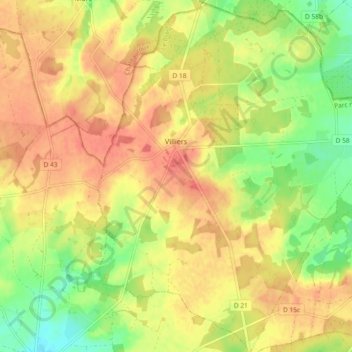
Name: Topografische Karte Villiers, Höhe, Relief.
Durchschnittliche Höhe: 131 m
Minimale Höhe: 100 m
Maximale Höhe: 153 m
Andere topografische Karten
Klicken Sie auf eine Karte, um ihre Topografie, ihre Höhe und ihr Relief anzuzeigen.
Roy
France > Centre-Val de Loire > Indre > Sainte-Gemme
Roy, Sainte-Gemme, Le Blanc, Indre, Centre-Val de Loire, Metropolitan France, 36500, France
Durchschnittliche Höhe: 104 m
Lacs
France > Centre-Val de Loire > Indre
Lacs, La Châtre, Indre, Centre-Val de Loire, Metropolitan France, 36400, France
Durchschnittliche Höhe: 224 m
Dun-le-Poëlier
France > Centre-Val de Loire > Indre
Dun-le-Poëlier, Issoudun, Indre, Centre-Val de Loire, Metropolitan France, 36210, France
Durchschnittliche Höhe: 112 m
Chavin
France > Centre-Val de Loire > Indre > Chavin
Chavin, Châteauroux, Indre, Centre-Val de Loire, Metropolitan France, 36200, France
Durchschnittliche Höhe: 230 m
Châteauroux
France > Centre-Val de Loire > Indre > Châteauroux
Châteauroux, Indre, Centre-Val de Loire, Metropolitan France, 36000, France
Durchschnittliche Höhe: 153 m
La Châtre
France > Centre-Val de Loire > Indre
La Châtre, Indre, Centre-Val de Loire, Metropolitan France, 36400, France
Durchschnittliche Höhe: 236 m