
Topografische Karte Fermo
Interaktive Karte
Klicken Sie auf die Karte, um die Höhe anzuzeigen.
Über diese Karte
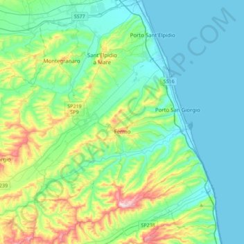
Name: Topografische Karte Fermo, Höhe, Relief.
Ort: Fermo, Marche, 63900, Italy (43.10584 13.48920 43.23440 13.82928)
Durchschnittliche Höhe: 98 m
Minimale Höhe: -2 m
Maximale Höhe: 459 m
Fermo is on a hill, the Sabulo, elevation 319 metres (1,047 ft), on a branch from Porto San Giorgio on the Adriatic coast railway.
Andere topografische Karten
Klicken Sie auf eine Karte, um ihre Topografie, ihre Höhe und ihr Relief anzuzeigen.
Montelparo
Montelparo, Fermo, Marche, 63853, Italy
Durchschnittliche Höhe: 366 m
Porto Sant'Elpidio
Porto Sant'Elpidio, Fermo, Marche, 63821, Italy
Durchschnittliche Höhe: 24 m