Geolokalisieren
👉 Easily get elevation data in JSON, GeoTIFF and KML formats using Elevation API
Vielen Dank für die Unterstützung dieser Website ❤️
Spenden

Topografische Karte Kilkenny

Klicken Sie auf die Karte, um die Höhe anzuzeigen.

Kilkenny

Kilkenny is situated in the Nore Valley on both banks of the River Nore, at the centre of County Kilkenny in the province of Leinster in the south-east of Ireland. It is 117 kilometres (73 mi) away the capital Dublin and 48 kilometres (30 mi) north from the nearest city Waterford. Wexford is 80 kilometres (50 mi) to the south-east and Limerick is 122 kilometres (76 mi) to the west. The elevation is 60 metres (200 ft) above mean sea level. The area of Kilkenny borough is 3.74 square kilometres (1.44 sq mi). The first edition of the Ordnance Survey map for Kilkenny was in 1837 and is held by the County Library.

Wikipedia (CC-BY-SA 3.0)

Über diese Karte

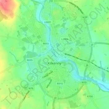
Name: Topografische Karte Kilkenny, Höhe, Relief.

Ort: Kilkenny, The Municipal District of Kilkenny City, County Kilkenny, Leinster, Ireland (52.63139 -7.27535 52.67721 -7.21688)

Durchschnittliche Höhe: 61 m

Minimale Höhe: 37 m

Maximale Höhe: 114 m

Andere topografische Karten

Klicken Sie auf eine Karte, um ihre Topografie, ihre Höhe und ihr Relief anzuzeigen.

Walton's Bog

Ireland > County Kilkenny

Durchschnittliche Höhe: 66 m

Coon

Ireland > County Kilkenny

Durchschnittliche Höhe: 221 m

Brandon Hill

Ireland > County Kilkenny

Brandon Hill (Irish: Cnoc Bhréanail) is the highest mountain in County Kilkenny, Ireland, with an elevation of 515 m (1,690 ft) and prominence at 448 m (1,470 ft). The South Leinster Way, a long-distance trail, meandering through the Barrow Valley and traverses Brandon Hill. The village of Graiguenamanagh and…

Durchschnittliche Höhe: 294 m

Foyleatalure

Ireland > County Kilkenny

Durchschnittliche Höhe: 216 m

Windgap

Ireland > County Kilkenny

Durchschnittliche Höhe: 149 m

Finsboro

Ireland > County Kilkenny

Durchschnittliche Höhe: 163 m

Ballyfoyle

Ireland > County Kilkenny

Durchschnittliche Höhe: 120 m

Owning

Ireland > County Kilkenny

Durchschnittliche Höhe: 97 m

Vielen Dank für die Unterstützung dieser Website ❤️
Spenden

Rüsten Sie sich für Ihr nächstes Abenteuer:

Als Amazon-Partner erhält diese Website eine Provision für qualifizierte Käufe, ohne zusätzliche Kosten für Sie.

Stonyford

Ireland > County Kilkenny

Durchschnittliche Höhe: 64 m

Hugginstown

Ireland > County Kilkenny

Durchschnittliche Höhe: 129 m

Brandon Hill

Ireland > County Kilkenny

Brandon Hill (Irish: Cnoc Bhréanail) is the highest mountain in County Kilkenny, Ireland, with an elevation of 515 m (1,690 ft) and prominence at 448 m (1,470 ft). The South Leinster Way, a long-distance trail, meandering through the Barrow Valley and traverses Brandon Hill. The village of Graiguenamanagh and…

Durchschnittliche Höhe: 294 m

Newmarket

Ireland > County Kilkenny > Newmarket

Durchschnittliche Höhe: 93 m

Jenkinstown Park

Ireland > County Kilkenny

Durchschnittliche Höhe: 77 m

Grangefertagh Round Tower

Ireland > County Kilkenny

Durchschnittliche Höhe: 121 m

Mount Alto

Ireland > County Kilkenny

Durchschnittliche Höhe: 168 m

Rüsten Sie sich für Ihr nächstes Abenteuer:

🗺️Topographische Karten Deutschland - Detaillierte topographische Karten für Outdoor‑Abenteuer
🥾Bergsteiger Ausrüstung Set - Komplettes Set für Bergexpeditionen
Outdoor Geschirr Set - Koch‑ und Essgeschirr für Camping
🎒Kinder Outdoor Schuhe - Haltbare Schuhe für junge Outdoor Fans
🩹Outdoor Pflaster Set - Wasserfeste Pflaster für unterwegs

Als Amazon-Partner erhält diese Website eine Provision für qualifizierte Käufe, ohne zusätzliche Kosten für Sie.