
Spenden
Rüsten Sie sich für Ihr nächstes Abenteuer:
Als Amazon-Partner erhält diese Website eine Provision für qualifizierte Käufe, ohne zusätzliche Kosten für Sie.
Topografische Karte Mono
Klicken Sie auf die Karte, um die Höhe anzuzeigen.
Spenden
Rüsten Sie sich für Ihr nächstes Abenteuer:
Als Amazon-Partner erhält diese Website eine Provision für qualifizierte Käufe, ohne zusätzliche Kosten für Sie.
Mono
Mono is a rural community in both geography and character. It has a wide variation in topography, being composed of mostly rolling, tree-covered hills. It holds many streams and creeks which form the headwaters of three rivers - the Humber River, Nottawasaga River and Credit River and most of the town is located on high land relative to the rest of Southern Ontario. This leads to its current slogan of 'the heart of the headwaters'.
Spenden
Rüsten Sie sich für Ihr nächstes Abenteuer:
Als Amazon-Partner erhält diese Website eine Provision für qualifizierte Käufe, ohne zusätzliche Kosten für Sie.
Über diese Karte
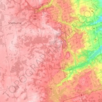
Name: Topografische Karte Mono, Höhe, Relief.
Ort: Mono, Dufferin County, Central Ontario, Ontario, Canada (43.92274 -80.17161 44.12324 -79.95119)
Durchschnittliche Höhe: 440 m
Minimale Höhe: 250 m
Maximale Höhe: 530 m
Spenden
Rüsten Sie sich für Ihr nächstes Abenteuer:
Als Amazon-Partner erhält diese Website eine Provision für qualifizierte Käufe, ohne zusätzliche Kosten für Sie.
Andere topografische Karten
Klicken Sie auf eine Karte, um ihre Topografie, ihre Höhe und ihr Relief anzuzeigen.
Spenden
Rüsten Sie sich für Ihr nächstes Abenteuer:
Als Amazon-Partner erhält diese Website eine Provision für qualifizierte Käufe, ohne zusätzliche Kosten für Sie.