
Spenden
Rüsten Sie sich für Ihr nächstes Abenteuer:
Als Amazon-Partner erhält diese Website eine Provision für qualifizierte Käufe, ohne zusätzliche Kosten für Sie.
Topografische Karte Saint Simons
Klicken Sie auf die Karte, um die Höhe anzuzeigen.
Spenden
Rüsten Sie sich für Ihr nächstes Abenteuer:
Als Amazon-Partner erhält diese Website eine Provision für qualifizierte Käufe, ohne zusätzliche Kosten für Sie.
Über diese Karte
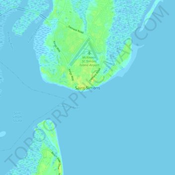
Name: Topografische Karte Saint Simons, Höhe, Relief.
Ort: Saint Simons, Glynn County, Georgia, 31522, United States (31.09538 -81.42952 31.17538 -81.34952)
Durchschnittliche Höhe: 2 m
Minimale Höhe: -3 m
Maximale Höhe: 14 m
Spenden
Rüsten Sie sich für Ihr nächstes Abenteuer:
Als Amazon-Partner erhält diese Website eine Provision für qualifizierte Käufe, ohne zusätzliche Kosten für Sie.
Andere topografische Karten
Klicken Sie auf eine Karte, um ihre Topografie, ihre Höhe und ihr Relief anzuzeigen.
Brunswick
United States > Georgia > Glynn County
The city is the lowest in the U.S. state of Georgia, with an elevation of only 10 to 14 feet (3.0 to 4.3 m) above sea level. According to the U.S. Census Bureau, Brunswick's land area is 32.4 square miles (83.8 km2). Its total area is 42.4 square miles (109.8 km2); 10.0 square miles (26.0 km2) of this is water.
Durchschnittliche Höhe: 2 m
Spenden
Rüsten Sie sich für Ihr nächstes Abenteuer:
Als Amazon-Partner erhält diese Website eine Provision für qualifizierte Käufe, ohne zusätzliche Kosten für Sie.