
Topografische Karte Barn Island
Interaktive Karte
Klicken Sie auf die Karte, um die Höhe anzuzeigen.
Über diese Karte
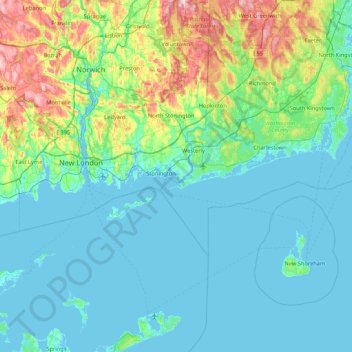
Name: Topografische Karte Barn Island, Höhe, Relief.
Ort: Barn Island, New London County, Connecticut, 06379, USA (41.00954 -72.18840 41.64954 -71.54840)
Durchschnittliche Höhe: 33 m
Minimale Höhe: -3 m
Maximale Höhe: 195 m
Andere topografische Karten
Klicken Sie auf eine Karte, um ihre Topografie, ihre Höhe und ihr Relief anzuzeigen.
The Plans
USA > Connecticut > Norwalk
The Plans, Norwalk, Fairfield, Connecticut, USA
Durchschnittliche Höhe: 0 m
Major Island
Major Island, New London County, Connecticut, USA
Durchschnittliche Höhe: 16 m
Lions Head
Lions Head, Litchfield County, Connecticut, 06968, USA
Durchschnittliche Höhe: 403 m
Hartford County
Windsor Locks, Hartford County, Connecticut, 06096, USA
Durchschnittliche Höhe: 36 m
Hartford
USA > Connecticut > Hartford
Hartford, Hartford County, Connecticut, USA
Durchschnittliche Höhe: 23 m