
Topografische Karte Waitsfield
Interaktive Karte
Klicken Sie auf die Karte, um die Höhe anzuzeigen.
Über diese Karte
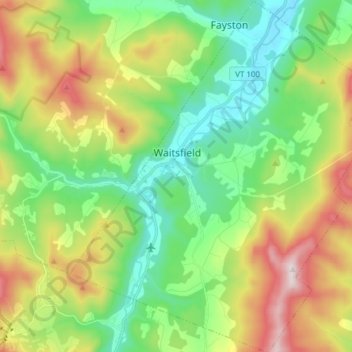
Name: Topografische Karte Waitsfield, Höhe, Relief.
Ort: Waitsfield, Washington County, Vermont, United States (44.13026 -72.86871 44.23957 -72.73779)
Durchschnittliche Höhe: 424 m
Minimale Höhe: 185 m
Maximale Höhe: 869 m
Andere topografische Karten
Klicken Sie auf eine Karte, um ihre Topografie, ihre Höhe und ihr Relief anzuzeigen.
Montpelier
United States > Vermont > Washington County
Montpelier, Washington County, Vermont, 05602, United States
Durchschnittliche Höhe: 284 m
Waterbury
United States > Vermont > Washington County > Waterbury
Waterbury, Washington County, Vermont, United States
Durchschnittliche Höhe: 199 m
Worcester
United States > Vermont > Washington County
Worcester, Washington County, Vermont, 05682, United States
Durchschnittliche Höhe: 461 m
Fayston
United States > Vermont > Washington County
Fayston, Washington County, Vermont, United States
Durchschnittliche Höhe: 504 m
Middlesex
United States > Vermont > Washington County > Middlesex
Middlesex, Washington County, Vermont, United States
Durchschnittliche Höhe: 330 m
Calais
United States > Vermont > Washington County > Calais
Calais, Washington County, Vermont, United States
Durchschnittliche Höhe: 363 m
South Cabot
United States > Vermont > Washington County > Cabot > South Cabot
South Cabot, Cabot, Washington County, Vermont, 05647, United States
Durchschnittliche Höhe: 480 m
Northfield
United States > Vermont > Washington County > Northfield
Northfield, Washington County, Vermont, 05663, United States
Durchschnittliche Höhe: 298 m