
Spenden
Rüsten Sie sich für Ihr nächstes Abenteuer:
Als Amazon-Partner erhält diese Website eine Provision für qualifizierte Käufe, ohne zusätzliche Kosten für Sie.
Topografische Karte Gaurikund
Klicken Sie auf die Karte, um die Höhe anzuzeigen.
Spenden
Rüsten Sie sich für Ihr nächstes Abenteuer:
Als Amazon-Partner erhält diese Website eine Provision für qualifizierte Käufe, ohne zusätzliche Kosten für Sie.
Über diese Karte
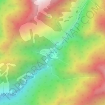
Name: Topografische Karte Gaurikund, Höhe, Relief.
Ort: Gaurikund, Ukhimath, Rudraprayag, Uttarakhand, India (30.63340 79.00682 30.67340 79.04682)
Durchschnittliche Höhe: 2.589 m
Minimale Höhe: 1.749 m
Maximale Höhe: 3.559 m
Spenden
Rüsten Sie sich für Ihr nächstes Abenteuer:
Als Amazon-Partner erhält diese Website eine Provision für qualifizierte Käufe, ohne zusätzliche Kosten für Sie.
Andere topografische Karten
Klicken Sie auf eine Karte, um ihre Topografie, ihre Höhe und ihr Relief anzuzeigen.
Budha Madmaheshwar
India > Uttarakhand > Ukhimath > Budha Madmaheshwar
Durchschnittliche Höhe: 3.045 m