
Topografische Karte Slim Lake
Interaktive Karte
Klicken Sie auf die Karte, um die Höhe anzuzeigen.
Über diese Karte
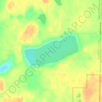
Name: Topografische Karte Slim Lake, Höhe, Relief.
Durchschnittliche Höhe: 404 m
Minimale Höhe: 383 m
Maximale Höhe: 418 m
Andere topografische Karten
Klicken Sie auf eine Karte, um ihre Topografie, ihre Höhe und ihr Relief anzuzeigen.
Devils Lake
United States > Wisconsin > Washburn County
Devils Lake, Town of Bass Lake, Washburn County, Wisconsin, United States
Durchschnittliche Höhe: 367 m
Tomahawk Lake
United States > Wisconsin > Washburn County
Tomahawk Lake, Town of Casey, Washburn County, Wisconsin, United States
Durchschnittliche Höhe: 318 m
Town of Spooner
United States > Wisconsin > Washburn County
Town of Spooner, Washburn County, Wisconsin, 54801, United States
Durchschnittliche Höhe: 342 m
Chicog Lake
United States > Wisconsin > Washburn County
Chicog Lake, Town of Chicog, Washburn County, Wisconsin, United States
Durchschnittliche Höhe: 314 m
Spooner
United States > Wisconsin > Washburn County
Spooner, Washburn County, Wisconsin, United States
Durchschnittliche Höhe: 336 m
Town of Chicog
United States > Wisconsin > Washburn County
Town of Chicog, Washburn County, Wisconsin, United States
Durchschnittliche Höhe: 310 m
Minong
United States > Wisconsin > Washburn County
Minong, Washburn County, Wisconsin, United States
Durchschnittliche Höhe: 330 m
Crystal Mountain
United States > Wisconsin > Washburn County
Crystal Mountain, Town of Spooner, Washburn County, Wisconsin, United States
Durchschnittliche Höhe: 344 m
Shell Lake
United States > Wisconsin > Washburn County
Shell Lake, Washburn County, Wisconsin, 53871, United States
Durchschnittliche Höhe: 376 m
Stone Lake
United States > Wisconsin > Washburn County
Stone Lake, Town of Stone Lake, Washburn County, Wisconsin, 54876, United States
Durchschnittliche Höhe: 405 m