
Topografische Karte Henry County
Interaktive Karte
Klicken Sie auf die Karte, um die Höhe anzuzeigen.
Über diese Karte
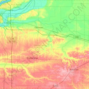
Name: Topografische Karte Henry County, Höhe, Relief.
Ort: Henry County, Illinois, United States of America (41.14967 -90.43968 41.58625 -89.85547)
Durchschnittliche Höhe: 214 m
Minimale Höhe: 170 m
Maximale Höhe: 270 m
According to the US Census Bureau, the county has a total area of 826 square miles (2,140 km2), of which 823 square miles (2,130 km2) is land and 2.7 square miles (7.0 km2) (0.3%) is water. It is the 29th largest of Illinois' 102 counties. The area is fairly flat, with elevations ranging from 650 feet above sea level in the northwest to 850 in the southeast. About 456,596 acres (1,847.78 km2) or 86.7% of the county's land area, is used for agriculture.
Andere topografische Karten
Klicken Sie auf eine Karte, um ihre Topografie, ihre Höhe und ihr Relief anzuzeigen.
Champaign County
United States of America > Illinois
Champaign County, Illinois, United States of America
Durchschnittliche Höhe: 217 m
Wayne County
United States of America > Illinois
Wayne County, Illinois, United States of America
Durchschnittliche Höhe: 133 m
Pike County
United States of America > Illinois
Pike County, Illinois, United States of America
Durchschnittliche Höhe: 184 m
Deerfield
United States of America > Illinois > Deerfield
Deerfield, Lake County, Illinois, 60015, United States of America
Durchschnittliche Höhe: 204 m
Woodlawn
United States of America > Illinois > Woodlawn
Woodlawn, Jefferson County, Illinois, United States of America
Durchschnittliche Höhe: 149 m
Gallatin County
United States of America > Illinois
Gallatin County, Illinois, United States of America
Durchschnittliche Höhe: 122 m
White County
United States of America > Illinois
White County, Illinois, United States of America
Durchschnittliche Höhe: 122 m
Cook County
United States of America > Illinois
Cook County, Illinois, United States of America
Durchschnittliche Höhe: 199 m
Alexander County
United States of America > Illinois
Alexander County, Illinois, United States of America
Durchschnittliche Höhe: 112 m