
Spenden
Rüsten Sie sich für Ihr nächstes Abenteuer:
Als Amazon-Partner erhält diese Website eine Provision für qualifizierte Käufe, ohne zusätzliche Kosten für Sie.
Topografische Karte Btorram
Klicken Sie auf die Karte, um die Höhe anzuzeigen.
Spenden
Rüsten Sie sich für Ihr nächstes Abenteuer:
Als Amazon-Partner erhält diese Website eine Provision für qualifizierte Käufe, ohne zusätzliche Kosten für Sie.
Über diese Karte
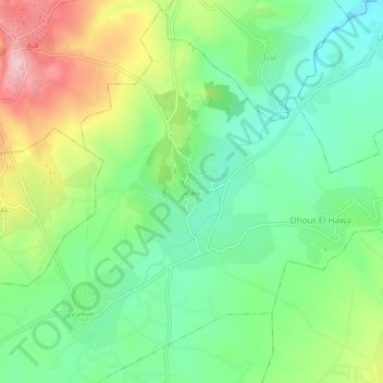
Name: Topografische Karte Btorram, Höhe, Relief.
Ort: Btorram, Koura District, North Governorate, 1306, Lebanon (34.31263 35.79005 34.35263 35.83005)
Durchschnittliche Höhe: 293 m
Minimale Höhe: 213 m
Maximale Höhe: 433 m
Spenden
Rüsten Sie sich für Ihr nächstes Abenteuer:
Als Amazon-Partner erhält diese Website eine Provision für qualifizierte Käufe, ohne zusätzliche Kosten für Sie.
Andere topografische Karten
Klicken Sie auf eine Karte, um ihre Topografie, ihre Höhe und ihr Relief anzuzeigen.
Zgharta District
The district at elevations from 40–2,550 metres (130–8,370 ft), from near the coast to its highest point in the Mount Lebanon mountain range.
Durchschnittliche Höhe: 527 m
Spenden
Rüsten Sie sich für Ihr nächstes Abenteuer:
Als Amazon-Partner erhält diese Website eine Provision für qualifizierte Käufe, ohne zusätzliche Kosten für Sie.
Spenden
Rüsten Sie sich für Ihr nächstes Abenteuer:
Als Amazon-Partner erhält diese Website eine Provision für qualifizierte Käufe, ohne zusätzliche Kosten für Sie.
Spenden
Rüsten Sie sich für Ihr nächstes Abenteuer:
Als Amazon-Partner erhält diese Website eine Provision für qualifizierte Käufe, ohne zusätzliche Kosten für Sie.
Tripoli
The urban form of Mamluk Tripoli was dictated mainly by climate, site configuration, defense, and urban aesthetics. The layout of major thoroughfares was set according to prevailing winds and topography. The city had no fortifications, but heavy building construction characterized by compact urban forms,…
Durchschnittliche Höhe: 42 m
Spenden
Rüsten Sie sich für Ihr nächstes Abenteuer:
Als Amazon-Partner erhält diese Website eine Provision für qualifizierte Käufe, ohne zusätzliche Kosten für Sie.
Spenden
Rüsten Sie sich für Ihr nächstes Abenteuer:
Als Amazon-Partner erhält diese Website eine Provision für qualifizierte Käufe, ohne zusätzliche Kosten für Sie.
Lazzab Dannieh Nature Reserve
Lebanon > North Governorate > Kfar Bebnine
Durchschnittliche Höhe: 1.439 m
Spenden
Rüsten Sie sich für Ihr nächstes Abenteuer:
Als Amazon-Partner erhält diese Website eine Provision für qualifizierte Käufe, ohne zusätzliche Kosten für Sie.
Tripoli
The urban form of Mamluk Tripoli was dictated mainly by climate, site configuration, defense, and urban aesthetics. The layout of major thoroughfares was set according to prevailing winds and topography. The city had no fortifications, but heavy building construction characterized by compact urban forms,…
Durchschnittliche Höhe: 42 m
Miniyeh
Miniyeh (Arabic: المنية, French: Minieh) is the capital of the Miniyeh-Danniyeh District in North Governorate of Lebanon. Minya is located 96 km from Beirut at an altitude of 20 m above sea level.
Durchschnittliche Höhe: 30 m
Tripoli
The urban form of Mamluk Tripoli was dictated mainly by climate, site configuration, defense, and urban aesthetics. The layout of major thoroughfares was set according to prevailing winds and topography. The city had no fortifications, but heavy building construction characterized by compact urban forms,…
Durchschnittliche Höhe: 42 m
Spenden
Rüsten Sie sich für Ihr nächstes Abenteuer:
Als Amazon-Partner erhält diese Website eine Provision für qualifizierte Käufe, ohne zusätzliche Kosten für Sie.
Spenden
Rüsten Sie sich für Ihr nächstes Abenteuer:
Als Amazon-Partner erhält diese Website eine Provision für qualifizierte Käufe, ohne zusätzliche Kosten für Sie.