
Topografische Karte Fort McMurray
Interaktive Karte
Klicken Sie auf die Karte, um die Höhe anzuzeigen.
Über diese Karte
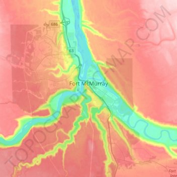
Name: Topografische Karte Fort McMurray, Höhe, Relief.
Ort: Fort McMurray, Wood Buffalo, Alberta, Canada (56.64375 -111.51094 56.80447 -111.20705)
Durchschnittliche Höhe: 345 m
Minimale Höhe: 234 m
Maximale Höhe: 422 m
The community lies at a lower elevation than most other parts of Alberta, so under the right conditions it can be a "hot spot" for Alberta.
Andere topografische Karten
Klicken Sie auf eine Karte, um ihre Topografie, ihre Höhe und ihr Relief anzuzeigen.
Namur Lake 174A
Canada > Alberta > Wood Buffalo
Namur Lake 174A, Wood Buffalo, Alberta, Canada
Durchschnittliche Höhe: 732 m
Anzac
Canada > Alberta > Wood Buffalo
Anzac, Wood Buffalo, Alberta, T0P 1J0, Canada
Durchschnittliche Höhe: 491 m
Fort Chipewyan
Canada > Alberta > Wood Buffalo > Fort Chipewyan
Fort Chipewyan, Wood Buffalo, Alberta, T0P 1B0, Canada
Durchschnittliche Höhe: 217 m