
Topografische Karte Shiono Cape
Interaktive Karte
Klicken Sie auf die Karte, um die Höhe anzuzeigen.
Über diese Karte
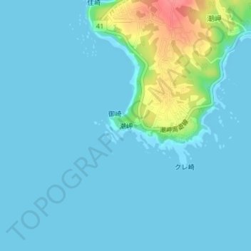
Name: Topografische Karte Shiono Cape, Höhe, Relief.
Durchschnittliche Höhe: 10 m
Minimale Höhe: 0 m
Maximale Höhe: 71 m
Geologically, the cape is a flat uplifted seafood plateau with an elevation of 60 to 80 meters consisting of two marine terraces, and a coastal cliff with a height of 40 meters. Originally an island, gravel from the estuary of nearby rivers is carried by coastal currents to form a sandbar, which now connects the island to land.