
Topografische Karte Leyte
Interaktive Karte
Klicken Sie auf die Karte, um die Höhe anzuzeigen.
Über diese Karte
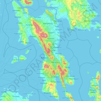
Name: Topografische Karte Leyte, Höhe, Relief.
Durchschnittliche Höhe: 68 m
Minimale Höhe: -1 m
Maximale Höhe: 1.238 m
Andere topografische Karten
Klicken Sie auf eine Karte, um ihre Topografie, ihre Höhe und ihr Relief anzuzeigen.
Baybay
Baybay, 5th District, Leyte, Eastern Visayas, 6521, Philippines
Durchschnittliche Höhe: 157 m
Macabug
Philippines > Leyte > Ormoc > Benolho
Macabug, Benolho, Ormoc, 4th District, Leyte, Eastern Visayas, 6541, Philippines
Durchschnittliche Höhe: 8 m
Quelao
Philippines > Leyte > Tolosa > Olot
Quelao, Olot, Tolosa, 1st District, Leyte, Eastern Visayas, 6503, Philippines
Durchschnittliche Höhe: 3 m
Dagami
Dagami, Leyte 2nd District, Leyte, Eastern Visayas, 6515, Philippines
Durchschnittliche Höhe: 119 m
Upper Utod (Guadalupe)
Philippines > Leyte > Baybay
Upper Utod (Guadalupe), Baybay, Leyte 5th District, Leyte, Eastern Visayas, 6521, Philippines
Durchschnittliche Höhe: 41 m
Naga-asan
Philippines > Leyte > Babatngon
Naga-asan, Babatngon, Leyte, Eastern Visayas, Philippines
Durchschnittliche Höhe: 44 m