
Topografische Karte Bou Ismaïl
Interaktive Karte
Klicken Sie auf die Karte, um die Höhe anzuzeigen.
Über diese Karte
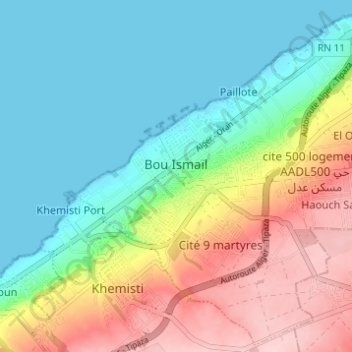
Name: Topografische Karte Bou Ismaïl, Höhe, Relief.
Ort: Bou Ismaïl, Daïra Bou Ismaïl, Tipaza, Algérie (36.61743 2.67242 36.66464 2.73382)
Durchschnittliche Höhe: 69 m
Minimale Höhe: -2 m
Maximale Höhe: 198 m
La ville de Bou-Ismaïl est située à cheval sur deux plaines, une basse légèrement inclinée vers la mer à 15 mètres d'altitude de moyenne et une haute à près de 110 mètres de hauteur. Les deux se rejoignent par un ravin abrupt. Elle est bordée à l'ouest par l'Oued Khemisti.
Andere topografische Karten
Klicken Sie auf eine Karte, um ihre Topografie, ihre Höhe und ihr Relief anzuzeigen.
Haouch Saboun
Algérie > Tipaza > Daïra Bou Ismaïl > Bou Ismaïl
Haouch Saboun, Bou Ismaïl, Daïra Bou Ismaïl, Tipaza, 42015, Algérie
Durchschnittliche Höhe: 140 m
Hamdania
Algérie > Tipaza > Daïra Bou Ismaïl > Bou Ismaïl
Hamdania, Bou Ismaïl, Daïra Bou Ismaïl, Tipaza, 42010, Algérie
Durchschnittliche Höhe: 119 m
Paillote
Algérie > Tipaza > Daïra Bou Ismaïl > Bou Ismaïl
Paillote, Bou Ismaïl, Daïra Bou Ismaïl, Tipaza, 42415, Algérie
Durchschnittliche Höhe: 43 m
Aïn Tagourait
Algérie > Tipaza > Daïra Bou Ismaïl
Aïn Tagourait, Daïra Bou Ismaïl, Tipaza, 42023, Algérie
Durchschnittliche Höhe: 64 m
Khemisti
Algérie > Tipaza > Daïra Bou Ismaïl
Khemisti, Daïra Bou Ismaïl, Tipaza, 42016, Algérie
Durchschnittliche Höhe: 147 m
Bouharoun
Algérie > Tipaza > Daïra Bou Ismaïl
Bouharoun, Daïra Bou Ismaïl, Tipaza, 42009, Algérie
Durchschnittliche Höhe: 134 m